This item has been sold, but you can enter your email address to be notified if another example becomes available.


|
||

|

|
|

|
Stock# 49001
Description
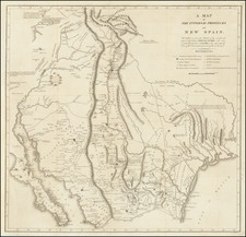
Important early map of the region between Fort Smith Arkansas and the Rio Grande River (Santa Fe, Taos, etc), prepared by the US Pacific Railroad Survey.
The primary cartographic detail is in the Rio Grande Valley of New Mexico and along the Canadian River, tracing the exploration route of this party through Indian Territory and northern Texas, on to the Rio Grande River, just south of Albuquerque.
The map was the product of the work of two of the most important western explorers and surveyors, AW Whipple and JC Ives, who would spend much of their professional careers exploring and mapping the west.
The map identifies a number of source maps that were utilized, including prior maps by
- Abert & Peck
- Captain Marcy
- Richard H. Kern
- Capt. Simpson
- Captain Sitgreaves
- Lt. Wiliamson
- E.G. Beckwith
Condition Description
Narrow left margin and some discoloration at folds.
![Official Texas Brags Map of North America . . . Scale One Inch = 6 Texas Grapefruit [With Original Envelope!]](https://storage.googleapis.com/raremaps/img/small/70748.jpg)
![[Mormon Trail] Utah And the Overland Routes to it, from the Missouri River: Published with](https://storage.googleapis.com/raremaps/img/small/66366.jpg)