|
||

|

|
|

|
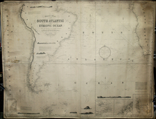
Finely executed Revolutionary War era sea chart of the North Atlantic Ocean, published in Paris by Jean Lattre.
The map extends from the coasts of Iceland and Greenland in the north to just below the Equator, with 4 profiles views shown in Africa, illustrating profiles on Cape Verde Island, Cap Mesurado and Cap Lopo.
The map illustrates the trading routes across the Atlantic to the Caribbean, New York, Boston and Newfoundland.
The outlines of the 13 Colonies are shown, as well as several French Forts, south of Lake Erie.
This chart is apparently quite rare on the market.
Jean Lattré (fl. 1743-1793) was a Parisian bookseller and engraver who published many maps, plans, globes, and atlases. He worked closely with other important French cartographers, including Janvier, Bonne, and Delamarche, as well as other European mapmakers, such as William Faden, Santini, and Zannoni. Lattré is also interesting due to his propensity to bring suits against those who copied his work; plagiarism was common practice in eighteenth-century cartography and mapmakers struggled to maintain proprietary maps and information.

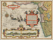
![[Hand Drawn Map] Le Golfe de Mexique avec les Pays Circonvoisins](https://storage.googleapis.com/raremaps/img/small/91580.jpg)