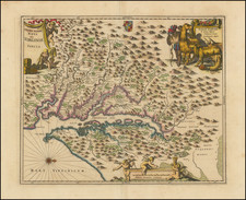
|
||

|

|
|

|
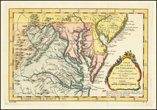
Nice example of this rare map of the Chesapeake region, which appeared in the Scots Magazine.
The map is derived from the Fry & Jefferson map, and identifies cities, counties, bays, islands, mountains, rivers, etc.
The map is unusual because of the "S" shape of the border between Delaware and Maryland in the area nea Wilmington. The Maryland State Archives entry for the map surmises that it is based upon a map published by John Bew in December 1780 (MSA Map #280B5), which is the only other map to give this particular border. Bew's map appeared in the Political Magazine, published in London.
The map is apparently quite scarce on the market, with no auction or dealer price records in AMPR going back 30 years. This is the second example we have seen on the market.
![La Florida [with] Guastecan [with] Peruviae Auriferae Regionis Typus](https://storage.googleapis.com/raremaps/img/small/84003.jpg)
![[Hand Drawn Map] Le Golfe de Mexique avec les Pays Circonvoisins](https://storage.googleapis.com/raremaps/img/small/91580.jpg)