This item has been sold, but you can enter your email address to be notified if another example becomes available.


|
||

|

|
|

|
Stock# 48480
Description
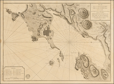
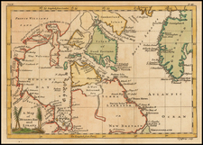
Interesting map of the Northern Pacific, showing the tracks of Captains Behring and Tschirkows Voyages of Exploration on the St. Peter and St. Paul, from Kamtschatka to the NW Coast of America and into the North East Passage, from 1728 to 1741.
Vitus Bering was required to cross Siberia and actually construct his own ships. The voyage was the first contact with the Alaskan Archipelago, which is shown in a very exagerated format.
There are several annotations showing discoveries along the Alaskan and NW Coast.
This is one of the earliest obtainable maps to report the contacts, having appeared in the London Magazine in 1764.
Reference
Jolly Lond-237