
The item illustrated and described below is sold, but we
have another example in stock. To view the example which
is currently being offered for sale, click the
"View Details" button below.
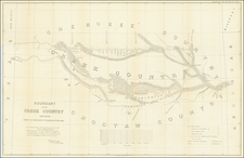
![[ Choctaw Nation ] Department of the Interior Commission on the Five Civilized Tribes Map of Choctaw Nation Indian Territory . . . 1904 By United States Department of the Interior](https://storage.googleapis.com/raremaps/img/small/70108.jpg)
1904 United States Department of the Interior
$ 245.00


|
||

|

|
|

|
Stock# 48392
Description
Striking map of the Choctaw Nation lands in Indian Territory, showing the Approximate Classifications of lands.
The map depicts the various land classifications in the Choctaw Nation, including Agricultural, Prairie, Hilly and Mountain Lands and Lands with and without Pine Timber. The map also depicts towns, roads, rivers, and other details.
Detailed and decorative for the period.
Condition Description
Several folds splits and tears, expertly repaired on verso.


![(Civil War) Fredericksburg … [with] Map… of the Sioux Expedition [with] Map of the Fight of the 14th A.C. Buzzard Roost, GA [and ] Big Mound [and] Dead Buffalo Lake [and] Dry Fort Creek](https://storage.googleapis.com/raremaps/img/small/97072.jpg)