|
||

|

|
|

|
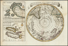
Map and text for The Southern Cross Expedition
Fine copy of Carsten Borchgrevink's map detailing the travels of the Southern Cross Expedition in Antarctica, in February 1900, including Borchgrevink's record setting "Furthest South".
Includes inset maps of:
- Camp Ridley
- Robertson's Bay
- South Pole
The map is accompanied by a report, entitled THE SOUTHERN CROSS EXPEDITION TO THE ANTARCTIC 1899-1900by Carsten Borchgrevink. From Vol. XVI of the Royal Geographical Society and Geographical Journal, London, 1900.
Disbound, 34pp., several photographic illustrations, plus a superb large folding colored map, laid on linen.
Borchgrevink would publish First on the Antarctic Continent, Being an Account of the British Antarctic Expedition 1898-1900, the following year, in 1901.
The Southern Cross Expedition
The Southern Cross Expedition, officially known as the British Antarctic Expedition 1898-1900, was the first British venture of the Age of Antarctic Exploration, and the forerunner of the more celebrated journeys of Robert Falcon Scott and Ernest Shackleton.
Conceived by the Norwegian-born, half-British explorer and schoolmaster Carsten Borchgrevink, this expedition was the first to over-winter on the Antarctic mainland, the first to visit the Great Ice Barrier since James Clark Ross's expedition of 1839 to 1843, and the first to effect a landing on the Barrier's surface. It also pioneered the use of dogs and sledges in Antarctic travel.
The expedition was privately financed by the British magazine publisher, Sir George Newnes. Borchgrevink's party sailed in the ship Southern Cross, and spent the southern winter of 1899, at Cape Adare, the northwest extremity of the Ross Sea coastline. Here they carried out scientific observations, although opportunities for inland exploration were severely restricted by the mountainous and glaciated terrain surrounding the base.
In January 1900, the party left Cape Adare in Southern Cross to explore the Ross Sea, following the route taken by Ross sixty years earlier. They reached the Great Ice Barrier, where a team of three made the first sledge journey on the Barrier surface, during which a new Farthest South record latitude was established at 78°50'S.
![[ Hudson Bay ] КАРТА ГУДЗОНСКАГО ЗАЛИВА (Carte de la Baye de Hudson)](https://storage.googleapis.com/raremaps/img/small/100628.jpg)