|
||

|

|
|

|
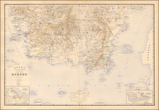
Ramusio's Map of the Indian Ocean and Evirons
Nice example of Giovanni Battista Ramusio's important early map of the Indian Ocean, one of the earliest printed maps to focus on the region.
The map is based on the latest Portuguese sources, whereupon the coastlines the peninsula of the Indian Subcontinent and Sri Lanka take on a modern form. However, one will notice that the mouth of the Indus is too pronounced, and is located far to the east, on the wrong side of Gujarat. The map gives primacy to various details ciritcal to the trade and commerce of the Portuguese Empire that dominated the Indian Ocean in the sixteenth-century. One will notice the key ports of Goa, Calicut, and Diu (in India), and Hormuz (in Persia), which were bulwarks of Lusitanian commerce.
Plying the seas inhabited by sea monsters are Carracks following standard sailing directions. The vessels labelled "Vado a Calicut" follow a course by which Portuguese ships turned east from the Horn of Africa at around 14 degrees North and sailed towards Calicut, following the same winds and currents as did Vasco da Gama in 1497. The carracks labelled "Vado alle Moluche" are headed towards the Spice Islands, then a source of vast riches.
The map shows the Indian subcontinent, the Strait of Horumz, the eastern half of the Gulf, and the Indian Ocean, including the islands of Ceylon (Sri Lanka), the Maldives, Seychelles, the western tip of Sumatra and what must be the eastern tip of Somalia. Many of the topographic names in the Gulf region derive from the forms used by Portuguese explorers, but they can be identified, sometimes tentatively, from their place on the map and from the early accounts of voyages: "Cor. Dulfar" (Dhofar), the island "Macira" (Masirah), "C. Resalgate" (Ras el Had?), Galatia (the ancient site Qalhat), "Mazcate" (Muscat), the island "Quexumo" (Qeshm), "Ormus" (Hormuz) and there is even an unlabelled city close to present-day Abu Dhabi. Two of the ships are labelled with their destinations: "Calicut" (Kozhikode) on the Malabar Coast and "Moluche" (the Moluccas) in the East Indies.
Ramusio's map, which appeared in his Delle Navigation e Viaggi, was subsequently copied by several Lafereri map makers. Ramusio's provides an update from Gastaldi's map of 1548, based upon new sources which became available during the intervening years.
Giovanni Battista Ramusio (1485-1557) was an Italian geographer who worked within the Venetian Empire. His father had been a magistrate and he himself served as a civil servant to Venice. He served throughout Europe, allowing him to build up a network of informants and a collection of travel materials. He compiled this information into his enduring masterpiece, Navigationi et Viaggi, in 1550 (first volume) and 1556 (third volume). The second volume appeared after his death in 1559, as the original manuscript had been destroyed by a fire.
![(Puducherry) Plan De La Ville De Pondicheri Dedie A La Memoire De Mr. Dupleix . . . 1748 . . . [Plan of the City of Pondicherry Dedicated to the Memory of Mr. Dupleix... 1748...]](https://storage.googleapis.com/raremaps/img/small/95813.jpg)