|
||

|

|
|

|
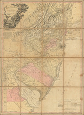
Scarce pre-Civil War map of New Jersey, colored by counties. Shows towns, roads, rivers, townships, etc.
The present map is an updated verion of Morse & Breese's map of New Jersey, issued by Charles Morse in his General Atlas of the World. Unlike the earlier maps by Morse & Breese, Charles Morse utilized color in his maps and also updated the geograpical information.
Morse & Breese's North American Atlas, was a landmark in American Cartography, being the first atlas to employ the cerographic printing process, which would revolutionize the map trade. The Morse family and this process are the subject of David Woodward's The All American Map. The maps were first printed in a series of inserts which appeared in the New York Post, and then later as a separate atlas.
An essential map for American Map collectors, illustrating an important change in the history of printed maps and the only truly American cartographic publishing innovation.