|
||

|

|
|

|
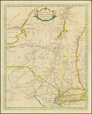
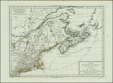
The first printed map to focus primarily on Connecticut and Rhode Island. A vital map for local collectors.
Important engraved map by Thomas Kitchin, published in the London Magazine in 1758.
Kitchin probably based the map on the 1737 survey by Gardner and Kellock, possibly via William Douglass' Plan of the British dominions of New England in North America (circa 1753). Kitchin's map actually includes more road and topographical detail than the much larger Douglass map. Likewise with the Braddock Mead map; despite being a fraction of the size of that map, the Kitchin manages to communicate more geographic information.
You can see the Library of Congress' example of the Douglass here: www.loc.gov/resource/g3720.ar079600/
Scarce. We find only one example at auction or in dealer catalogs in the last 40 years.
Thomas Kitchin was a British cartographer and engraver. Born in Southwark, England, Kitchin was the eldest of several children. He was apprenticed to the map engraver Emanuel Bowen from 1732 to 1739, and he married Bowen’s daughter, Sarah, in December 1739. By 1741 Kitchin was working independently and in 1746 he began taking on apprentices at his firm. His son Thomas Bowen Kitchin was apprenticed to him starting in 1754. By 1755 Kitchin was established in Holborn Hill, where his firm produced all kinds of engraved materials, including portraits and caricatures. He married his second wife, Jane, in 1762. Beginning in 1773 Kitchin was referred to as Hydrographer to the King, a position his son also later held. He retired to St. Albans and continued making maps until the end of his life.
A prolific engraver known for his technical facility, clean lettering, and impressive etched decorations, Kitchin produced several important works throughout his career. He produced John Elphinstone’s map of Scotland in 1746, and the first pocket atlas of Scotland, Geographia Scotiae, in 1748/1749. He co-published The Small English Atlas in 1749 with another of Bowen’s apprentices, Thomas Jefferys. He produced The Large English Atlas serially with Emanuel Bowen from 1749 to 1760. The latter was the most important county atlas since the Elizabethan era, and the first real attempt to cover the whole country at a large scale. In 1755 Kitchin engraved the important John Mitchell map of North America, which was used at the peace treaties of Paris and Versailles. In 1770 he produced the twelve-sheet road map England and Wales and in 1769–70 he produced Bernhard Ratzer’s plans of New York. In 1783, he published The Traveller’s Guide through England and Wales.