


|
||

|

|
|

|
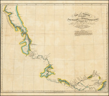
Rare German edition of Alexander Emile Lapie's map of Alaska, Canada, and the Polar Regions.
The map was originally published in the Nouvelles Annales du Voyages, in 1821, in order to illustrate a scholarly article examining the newest discoveries in search for the Northwest Passage and surveying the mythical accounts of earlier explorers in the region, including
- Admiral De Font (1640)
- Captain Lorenzo Ferrer Maldonado (1588)
- Captain Bernarda (1640)
Captain Maldonado was credited by some in early times with the discovery of the Straits of Anian, a key factor in the quest for the Northwest Passage. His routes through the region are shown in the farthest north reaches of the map.
Captain Bernarda, a mythical Spanish Sea Captain, is credited with sailing from the Pacific To Baffin's Bay, in1640.
The mythical Admiral De Font, who reportedly coasted the Pacific Northwest in 1640, before discovering the Northwest Passage, are shown. De Font's route veered inland via the Kings River (Reyes Fl) in southern Alasks, then via the Parmentier Rier to a Strait (Roquillo Strait) leading to Hudson's Bay.
The map extends from Fort Astoria, the Columbia River and the Lewis Fork in the south, to the North Polar Regions, providing a fine combination of the mythical discoveries of these early mariners with the best available details on the search for the Northwest Passage, including locating the discoveries of Mackenzie (1789) and Hearne (1771).
A fascinating combination of myth and modern cartographic information.
This is the first time we have ever seen this edition of the map.
![[Vancouver] Fraser River and Burrard Inlet](https://storage.googleapis.com/raremaps/img/small/68029.jpg)
![[Parts for a Klinger globe]](https://storage.googleapis.com/raremaps/img/small/46375.jpg)

![(Strait of Magellan) Freti Magellanici ac novi Freti vulgo Le Maire exactissima delineatio. [The most exact delineation of the Strait of Magellan and the new Strait, commonly known as Le Maire.]](https://storage.googleapis.com/raremaps/img/small/99612.jpg)