|
||

|

|
|

|
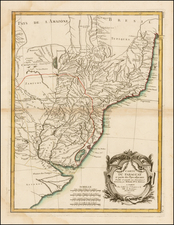
In the late 1630s, Holland attempted to reassert its colonial presence along the Brazilian Coastline, by establishing a series of forts. One of the best-documented colonies was the expedition led by Prince Maurits of Nassau, who attempted to set up an intellectual court in the New World. He brought with him a group of highly accomplished artists, mapmakers, and scientists to record the mysteries of Brazil. They included the celebrated painter Frans Post and the astronomer George Markgraf, who produced first serious study of the southern sky. Post painted a wealth of images of the Brazilian landscape and the surrounding vegetation and wildlife. His works are some of the earliest European paintings of Brazil. This view shows Fort Prince William near the Afogados River. Prince William was a square fort, which stood on a low plateau near the banks of the river. It had four bulwarks, strong palisades, and a high wooden The church that is pictured in the middle of the fort was the tallest structure in the camp, and could be seen all the way from Olinda. Prince William was a small outpost housing only 263 men and few slaves. This view appeared in John Ogilby's America: Being the Latest, and Most Accurate Description of the New World, published in London in 1671. Ogilby drew heavily from the work of Arnoldus Montanus, but added a significant amount of new material.
John Ogilby (1600-1676) was an English geographer and publisher, one of the most prominent of the seventeenth century. Little is known of his early life but by 1619 he was apprenticed to John Draper, a dancing-master in London. He worked as a dancing-master, courtier, and theater owner form 1620-1641. From 1649 he worked as a poet, translator, and publisher of classical texts. It is only in the last decade of his life that he entered into geography.
In 1649, Ogilby published his first translation, of Virgil, and continued to put out translations in the 1650s and 1660s. In March 1661 he was reconfirmed as master of revels in Ireland and appointed master of the king’s imprimeries, or king’s printer. From 1662 to 1665 he was in Ireland, where he most likely met Robert Boyle. He returned to London only to lose much of his printing stock in the Great Fire of 1666. Post-fire, he became assistant surveyor to the city, where he met Robert Hooke and Christopher Wren.
In 1669, Ogilby published Embassy to China. At the same time, he planned to release atlases that would cover the entire world. These atlases would be funded via subscriptions, advertisements, and lotteries—all common practice at the time, especially for expensive multi-volume works. He released Africa and Atlas Japannensis in 1670, America in 1671 and Atlas Chinensis in 1671, and Asia in 1673. Ogilby compiled the works based on materials produced by others and they reflect a growing interest in the wider world within England.
In 1671, while producing the atlases, Ogilby secured another royal title, that of his Majesty’s cosmographer. He used this title when publishing Britannia in 1675, his best-known work. The Britannia is best described as a road atlas; it shows 2519 miles of road in 100 strip maps. This technique would be widely adopted in the subsequent century. His method of measuring with a waywiser, a large wheel, also helped to standardize the distance of the English mile at 1760 yards. The Britannia was a major achievement in early English cartography and was republished in 1698, 1719, and 1720.