|
||

|

|
|

|
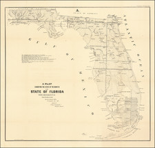
"The First Great Map of Florida After Statehood"
Fine large format map of Florida, published shortly after its admission to the Union on March 3, 1845.
The map is by far the most detailed and accurate map of Florida to date, including the progress of the General Land Office surveys and several of the ealy Land Grants. Numerous forts, military camps, counties, early roads, towns, lakes rivers, etc. The surveys extend south to the Fort Dallas (Miami) area on the east coast and on the west coast to Charlotte Harbor.
Most of the southern part of the state is unsurveyed. Curiously the map is still divided between East Florida and West Florida.
A note in the western Everglades marks the "district assigned to the Seminoles by the arrangement of Gen. Macomb May 18th 1839" and further remarks "N.B. 20 miles around this district is reserved from survey till the Seminoles are removed."
Joseph Goldsborough Bruff was a civilian draftsman and artist with the Bureau of Topographical Engineers. He participated in the California Gold Rush, and also worked on the United States Capitol as a designer and draftsman. Bruff's earliest important map was issued by Henry S. Tanner in 1839, and was of the lands ceded by Indian tribes to the U.S. government by treaty, and lands occupied by the tribes. Bruff went on to produce important maps during the Mexican War (of the Isthmus of Tehuantepec) and the Civil War (of battles in Virginia and Maryland).
Includes large inset maps of Key West; mouths of Swanee River & Cedar Keys; area between Cedar Keys and St. John's River.
The following link offers a 2 minute video by map collector Thomas Touchton, discussing the importance of the map: https://www.youtube.com/watch?v=pZssz5J34Cw
The map is relatively scarce on the market, especially in such fine condition.
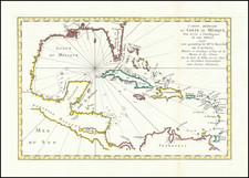
![Island of Cuba (Spanish) and Jamaica (British) [also South Florida, Bahamas and Cayman Islands]](https://storage.googleapis.com/raremaps/img/small/98323.jpg)
![[ Florida Native Americans Procession For The New Queen ] Qua pompa Regina delecta ad Regem deferatur](https://storage.googleapis.com/raremaps/img/small/98175.jpg)