|
||

|

|
|

|
Stock# 47712
Description
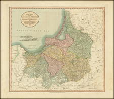
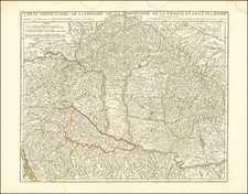
A fabulous regional map of Bohemia, Moravia, Silesia, Eger and Glatz, showing many long lost provincial borders, including Pilsen, Saatz, Leutmeritz, Buntzlau, Konigsgratz, Glatz, Olmutz, Chrudim, Cazslau, Kaurzim, Beraun, Rakonitz, Prachin, Bechin, Eger, and small area on the Bavarian border called Royal Free Peasants.
Shows towns, rivers, mountains, etc. Large table of Bohemian states.
Striking engraving and original wash colors. Robert Wilkinson was active in London as a cartographic publisher from 1785 to 1825. He produced a number of nice works, including a General Atlas and a re-issuance of Bowen & Kitchen's English Atlas, along with excellent large format separate maps.
![[ Siege of Krakow ] Was gestalt des Koniges in polen Sigismundi Braut Anna Caroli, Ertzhertzogen Von Osterreich Christmilter gedechnus Tochter, den 28 Mayus. 92 bij Crocaw . . .](https://storage.googleapis.com/raremaps/img/small/98964.jpg)