


|
||

|

|
|

|
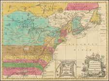
Perhaps The Rarest of Aaron Arrowsmith's Maps of the Americas -- Utilized For The Alaskan Boundary Tribunal
Nice example of the first state of Aaron Arrowsmith's second map of the Americas, first published in 1822.
The present map replaces Arrowsmith's first and significantly smaller map of the United States, first issued in 1804: /gallery/detail/48822
This remarkable large-format map of North and South America by the United States and Canada as part of the resolution of the Alaskan Boundary Dispute in 1903, which finally settled the Alaskan border.
Arrowsmith's map reveals the western hemisphere as it began a century of nation-building, political development, and geographic exploration. It shows both continents to their northern and southern extremes, with Tierra del Fuego as an inset. The map is an excellent example of early-nineteenth century mapping, with its unadorned style and lack of decoration, it seems to exude precision and authority. However, certain geographic features reveal continuing political and geographic uncertainty.
For example, despite declarations of independence in Mexico (1810), Chile (1810), Colombia (1810), Venezuela (1811), Paraguay (1811), and Argentina (1816), the territory is still shown as if Spain ruled from California to Patagonia. The unity belies the fierce fighting that Spanish and colonial forces were engaged in, resulting in a very different political map by the mid-1820s. However, Arrowsmith chose not record these struggles, perhaps because he was unsure of precise borders as the factions created, dissolved, and moved borders. John Arrowsmith, Aaron's nephew, would map these new boundaries in the 1830s.
Farther north, the map displays detailed information of the Hudson Bay Company's discoveries on the Columbia River and the Upper Missouri River. The Columbia River and its tributaries are well delineated as they extend toward the Rocky Mountains, while the Missouri fans out to the east. Interspersed amongst these waterways are the names of indigenous groups who were then the only permanent human inhabitants of these areas.
The Rocky Mountains are also the terminus point for the border of official British influence-their pink line of possession halts at the eastern slopes. Of course, the Hudson's Bay Company and other British subjects were already operating farther west, but the precise areas of control were a point of contention between indigenous peoples, Americans, and the British. In 1818, British and American diplomats signed a treaty agreeing to share the territory, a solution that proved untenable as more and more Americans streamed into the territory by the 1830s. Tensions built until James K. Polk made the border a priority in his 1844 campaign with the slogan, "54'40" or fight!". After winning the election, however, Polk and the British decided upon the 49th parallel as the northern border of Oregon Territory in 1846. Only two years later, in the Treaty of Guadalupe-Hidalgo, the US gained what would become the states of California, Arizona, New Mexico, Colorado, Utah, and Wyoming. Thus, Arrowsmith's map is a snap-shot of the Americas on the verge of political realignment.
Even farther north, the Arctic explorations of William Hearne, William Edward Parry and John Ross influenced Arrowsmith, as seen in the depiction of the Great Slave Lake and Lancaster Sound in the northwest of Baffin Bay. Hearne had trekked overland in the 1770s as an employee of the Hudson's Bay Company. His journals, published posthumously in 1795, were influential for mapmakers. Ross' 1818 expedition was a failure; Ross turned back when he assumed mountains blocked Lancaster Sound. Parry, who captained the accompanying vessel, was disgusted. He returned in 1819 as the head of a new expedition in search of the Northwest Passage. Parry entered the Sound and wintered there in 1819-20; his was the first expedition to cross 110° West, a feat for which the voyage received £5,000 from Parliament.
Parry was on another expedition when this map was published. Also in 1822, John Franklin returned from his first overland expedition in the footsteps of Hearne; eleven of his twenty men had died and cannibalism was suspected. However, Franklin would become a hero, fueling interest in the High Arctic and the search for the Northwest Passage. Exploration, British interests in the Oregon Territory, and the rapidly developing political situation in South America all combined to create considerable interest in the Americas in the 1820s. Europe was healing from the Napoleonic Wars and was interested in looking outward; maps like this turned that gaze on Americas as a land of opportunity from the far north to the far south.
Another edition of the map was released in 1824 with more detail in the Arctic, just as Franklin's celebrated account of his first expedition came to market. In 1823, between the 1822 and 1824 editions, Aaron Arrowsmith died. He had been active as a mapmaker since 1790 and had developed his business at three successive London locations. Part of Aaron's success was based on his personal and professional relationships with some of the most important bodies for the provision and use of maps, the Royal Navy Hydrographic Office, where Aaron worked for a short time, and the Hudson's Bay Company. In 1810 he was named Hydrographer to the Prince of Wales; in 1820, he became Hydrographer to the King, the title used on this map. When he died, his sons, Aaron Jr. and Samuel, took over the business, which continued until Aaron Sr.'s nephew, John, died in 1873. The entire stock was sold at auction in 1874.
The map was issued in 2 states, the 1822 and an extensively corrected example, issued in 1824.
We note only 2 examples of the 1822 edition (Clements Library and JCB). The example of the 1824 edition in the collection at the University of Alaska Fairbanks was used in the International Boundary Tribunal for the Alaskan Boundary and there is reference to the map in the US Supreme Court arbitration of a seal fur dispute (Fur seal arbitration, Volume 15, by the Bering Sea Tribunal of Arbitration, United States. 53d Congress, 2d session, Senate).
http://www.rmg.co.uk/discover/explore/search-north-west-passage
The Arrowsmiths were a cartographic dynasty which operated from the late-eighteenth century to the mid-nineteenth. The family business was founded by Aaron Arrowsmith (1750-1823), who was renowned for carefully prepared and meticulously updated maps, globes, and charts. He created many maps that covered multiple sheets and which were massive in total size. His spare yet exacting style was recognized around the world and mapmakers from other countries, especially the young country of the United States, sought his maps and charts as exemplars for their own work.
Aaron Arrowsmith was born in County Durham in 1750. He came to London for work around 1770, where he found employment as a surveyor for the city’s mapmakers. By 1790, he had set up his own shop which specialized in general charts. Arrowsmith had five premises in his career, most of which were located on or near Soho Square, a neighborhood the led him to rub shoulders with the likes of Joseph Banks, the naturalist, and Matthew Flinders, the hydrographer.
Through his business ties and employment at the Hydrographic Office, Arrowsmith made other important relationships with Alexander Dalrymple, the Hudson’s Bay Company, and others entities. In 1810 he became Hydrographer to the Prince of Wales and, in 1820, Hydrographer to the King.
Aaron Arrowsmith died in 1823, whereby the business and title of Hydrographer to the King passed to his sons, Aaron and Samuel, and, later, his nephew, John. Aaron Jr. (1802-1854) was a founder member of the Royal Geographical Society (RGS) and left the family business in 1832; instead, he enrolled at Oxford to study to become a minister. Samuel (1805-1839) joined Aaron as a partner in the business and they traded together until Aaron left for the ministry. Samuel died at age 34 in 1839; his brother presided over his funeral. The remaining stock and copper plates were bought at auction by John Arrowsmith, their cousin.
John (1790-1873) operated his own independent business after his uncle, Aaron Arrowsmith Sr., died. After 1839, John moved into the Soho premises of his uncle and cousins. John enjoyed considerable recognition in the geography and exploration community. Like Aaron Jr., John was a founder member of the RGS and would serve as its unofficial cartographer for 43 years. Several geographical features in Australia and Canada are named after him. He carried the title Hydrographer to Queen Victoria. He died in 1873 and the majority of his stock was eventually bought by Edward Stanford, who co-founded Stanford’s map shop, which is still open in Covent Garden, London today.

![Gen. Washington [On The Battlefield At Trenton] Engraved by W. Warner from the original picture by Col John Trumbull](https://storage.googleapis.com/raremaps/img/small/103233.jpg)