|
||

|

|
|

|
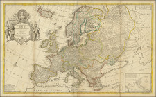
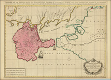
Pro-Red Army Propaganda Map Published in the British Empire.
Fascinating WWII broadside propaganda map, published in India, in order to keep the local populous informed about the War.
The map shows the Eastern Front of the war in Europe, between Leningrad and the Caucasus.
The caption above the map reads:
The second Russian winter offensive lasted four months and twenty days. Setting out from Voronezh, on the Don, Stalingrad, on the Volga, and Ordzhonikidze, in the Caucasus, the Red Army pressed forward to deal shattering blows at the German armies in the south and to liberate no less than 186,000 square miles of Russian soil--most of which had been seized during Hitler's offensive last summer.
In those four months and twenty days the Red Army captured or destroyed 5,090 planes, 9,290 tanks and 20,360 guns. Casualties inflicted on the enemy were: 850,000 killed, 343,525 taken prisoner and an unknown number wounded.
An interesting Eastern Front map, with special appeal having been printed in India.
![(First state!) [ Poland, Hungary, Romania, Bulgaria, Ukraine, Serbia ] Polonia Et Ungaria XV Nova Tabula](https://storage.googleapis.com/raremaps/img/small/94631.jpg)