|
||

|

|
|

|
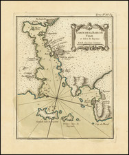
From the First Printed Rutter, and the Most Beautiful of the Period.
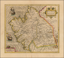
Nice example of Wagenhaer's map of the Galician Coastline, from Cape Finisterre to Caminha. The map covers Vigo, Pontevedra, Muros, Noia, Ribeira and most of the west facing part of the northwest coast of Spain.
The map is designed primarily for navigational use, which is why it contains numerous soundings and the locations of shoals, anchorages, and reefs. The sea coasts are shown in an innovative fashion which represent the topography as they would be visible from the coast. A detailed treatment of the Cap Finistere is provided at the top, which is one of the most critical capes for navigation in Europe.
Lucas Wagenhaer was a Dutch pilot who produced the first set of effective navigational charts, under the title Spiegel der Zeevaerdt. These gorgeous charts, engraved by Baptist and Jan van Doetecum, embody the latest contemporary knowledge of navigation and position finding, and set the standard which was followed for more than a century. Waghenaer's charts are magnificent works of art, which are highly sought after by collectors.
Waghenaer was a Dutch marine cartographer and navigator who grew up in the important port of Enkuizen. From 1550-1579 he served at sea, increasing his practical knowledge of sailing and charting. His first publication was the aformentioned famous Spiegel der Zeevaerdt, or Mariner's Mirror, which appeared in 1584. The work was reprinted and translated into several European languages. The combination of detailed charts accompanied by sailing directions set a precedent and model for subsequent sea atlases, which came to be called waggoners. Waghenaer published two other works, Thresoor der Zeevaert ( Treasure of navigation) in 1592 and the Enchuyser zeecaertboeck (Enkhuizen sea-chart-book) in 1598. He died in 1606.
An essential map for collectors of the region as this is the earliest decorative sea chart of the region.