|
||

|

|
|

|
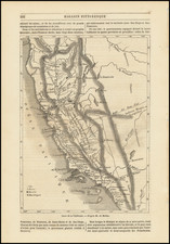
Rare revised and updated separately issued US Coast Survey Chart of the Coast of California, of one of the earliest coastal charts of the California Coastline produced in America.
The present example has been revised and updated from the original edition, which included the designation "J. No. 10" above the title. In this edition, there are a number of additional place names and some changes in the coastline and topography, most notably near Point Reyes, Drakes Bay and Bolinas Bay, where there are also added soundings. There are also changes in San Diego Harbor, Pt. Buenaventura is added, the spelling of Pt. Arguello is corrected, the name Monte del Buchon is added near San Luis Obispo,
The chart includes 17 views of various parts of the California Coastline, including San Francisco Bay, Pt. Piedras, Pt. Ano Nuevo, Pt. Sur, Pt. Pinos, Moro Rock, Pt. Sal, Pt. Arguilla, Pt. Conception, Pt. Duma, Santa Barbara, San Pedro, the Southern Part of San Diego, Pt. Loma and Catalina Harbor. A highly detailed map, with soundings, sailing directions and other interesting features.
Fine example of this rare updated variant edition.
The United States Office of the Coast Survey began in 1807, when Thomas Jefferson founded the Survey of the Coast. However, the fledgling office was plagued by the War of 1812 and disagreements over whether it should be civilian or military controlled. The entity was re-founded in 1832 with Ferdinand Rudolph Hassler as its superintendent. Although a civilian agency, many military officers served the office; army officers tended to perform the topographic surveys, while naval officers conducted the hydrographic work.
The Survey’s history was greatly affected by larger events in American history. During the Civil War, while the agency was led by Alexander Dallas Bache (Benjamin Franklin’s grandson), the Survey provided the Union army with charts. Survey personnel accompanied blockading squadrons in the field, making new charts in the process.
After the Civil War, as the country was settled, the Coast Survey sent parties to make new maps, employing scientists and naturalists like John Muir and Louis Agassiz in the process. By 1926, the Survey expanded their purview further to include aeronautical charts. During the Great Depression, the Coast Survey employed over 10,000 people and in the Second World War the office oversaw the production of 100 million maps for the Allies. Since 1970, the Coastal and Geodetic Survey has formed part of the National Oceanic and Atmospheric Administration (NOAA) and it is still producing navigational products and services today.
![[ Orange County ] Geological Sketch Map S.E. Portion of Orange Co. California State Mining Bureau . . .](https://storage.googleapis.com/raremaps/img/small/76946.jpg)