|
||

|

|
|

|
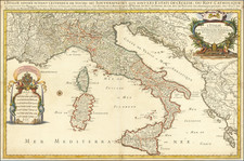
Attractive Santini edition of de Vaugondy's map of northern Italy and western Austria.
Excellent map of the Austrian, Swiss, Italian and German Alps, extending from Lake Constance in the northwest to Lago Garda in the South, showing Innsbruck, Trente, and most of the great Austrian and Italian Alpine Ski country.
Shows fortified cities, towns, rivers, castles, churches, roads, woods, mountains, lakes, etc. Very detailed.
Large decorative title cartouche.
Gilles Robert de Vaugondy (1688-1766) and Didier Robert de Vaugondy (1723-1786) were influential figures in the realm of 18th-century French cartography. Originating from Paris, their contributions to mapmaking were significant during an era of expansive geographical exploration.
Gilles Robert de Vaugondy entered the world of cartography not through family tradition but through personal interest and the budding opportunities of his time. Born in 1688, he worked during a time when Paris was becoming a central hub for cartographic activities. Gilles often incorporated the latest findings from explorers into his maps, making them sought-after for their contemporary relevance. His connections weren't limited to his immediate circle; he frequently interacted with other key mapmakers, staying updated on the latest techniques and findings.
His son, Didier, was born in 1723 and had the advantage of growing up surrounded by maps and globes. While his father was renowned for maps, Didier made a name for himself in the field of globemaking. His globes were some of the most precise and detailed in France, gaining recognition even among the royalty. In addition to his work in cartography and globemaking, Didier had a keen interest in education, especially after the expulsion of the Jesuits from France. He stepped in to produce geographical educational materials, fulfilling a newfound need.
The maps and globes produced by the Vaugondys remain an enduring testament to the peak of French cartography during the Enlightenment. Their works, characterized by precision and the inclusion of contemporary findings, helped to shape our understanding of the world during a transformative period in European history.
Paolo Santini (1729-1793) was an Venetian engraver known especially for his religious prints and fine cartographic engravings. He published in Venice and may have a been a member of the clergy. In his maps, he largely adopted and adapted the work of his French counterparts, especially the brothers de Vaugondy.
![[ Austro-Turkish War ] Zum ersten quartal des Krigsweisers](https://storage.googleapis.com/raremaps/img/small/97836.jpg)
![[ Bern, Switzerland ] Inclytae Urbis et Ditionis Bernensis cum locis finitimis Tabula Geographica et Hydrographica noviter correcta](https://storage.googleapis.com/raremaps/img/small/99812.jpg)