|
||

|

|
|

|
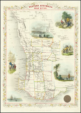
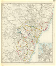
Rare early map of New South Wales, published by John Wyld.
The present example shows the Gold Deposits in New South Wales.
We date the map based upon the appearance of Rodney County, Victoria, which was established in 1871.
As noted on the map, the map depicts the Gold Discoveries in the Southern part of the map. In 1851, gold was first discovered in Clunes and Buninyong, near Ballarat, and subsequently at Bendigo. Later discoveries occurred at many sites across Victoria. This triggered one of the largest gold rushes the world has ever seen. The colony grew rapidly in both population and economic power. In ten years the population of Victoria increased sevenfold from 76,000 to 540,000. All sorts of gold records were produced including the "richest shallow alluvial goldfield in the world" and the largest gold nugget. Victoria produced in the decade 1851-1860, twenty million ounces of gold, one third of the world's output.
James Wyld Sr. (1790-1836) was a British cartographer and one of Europe’s leading mapmakers. He made many contributions to cartography, including the introduction of lithography into map printing in 1812.
William Faden, another celebrated cartographer, passed down his mapmaking business to Wyld in 1823. The quality and quantity of Faden’s maps, combined with Wyld’s considerable skill, brought Wyld great prestige.
Wyld was named geographer to Kings George IV and William IV, as well as HRH the Duke of York. In 1825, he was elected an Associate of the Institution of Civil Engineers. He was one of the founding members of the Royal Geographical Society in 1830. Also in 1830, his son, James Wyld Jr., took over his publishing house. Wyld Sr. died of overwork on October 14, 1836.
James Wyld Jr. (1812-87) was a renowned cartographer in his own right and he successfully carried on his father’s business. He gained the title of Geographer to the Queen and H.R.H. Prince Albert. Punch (1850) described him in humorous cartographic terms, “If Mr. Wyld’s brain should be ever discovered (we will be bound he has a Map of it inside his hat), we should like to have a peep at it, for we have a suspicion that the two hemispheres must be printed, varnished, and glazed, exactly like a pair of globes.”
![[South Australia] Ports in the Gulf of St. Vincent and Encounter Bay Surveyed by Comr. J. Hutchinson R.N. and assisted by F. Howard & M.S. Guy Navl. Lieutts. R.N. 1869 (Port Victor, Port Elliott, Port Willunga and Port Noarlunga)](https://storage.googleapis.com/raremaps/img/small/38744.jpg)
![(Australia) Australien - Ubersicht des Standpunkets der geographischen Kenntniss von Australien, 1868, & Dr. Neumayer's Projeket zur wisseschaftlichen Erforschung Central-Australiens [Survey of the Standpoint of the Geographical Knowledge of Australia, 1868, & Dr. Neumayer's project for the scientific investigation of central Australia]](https://storage.googleapis.com/raremaps/img/small/85398.jpg)