|
||

|

|
|

|
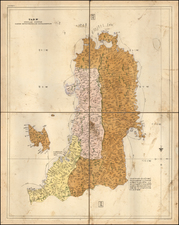
A Monumental Map of Japan
Engelbert Kaempfer's map of Japan, featured in the 1729 Dutch edition of his 'History of Japan', is an important artifact of cartography and cultural exchange. Drawn from Kaempfer's original maps by Johann Caspar Scheuchzer, it provides a historical record of Japan's geography and an insight into the intermingling of Eastern and Western knowledge during the 17th century.
Kaempfer, a Swedish physician and diplomat, made his historic journey to Japan in the late 17th century as part of the Dutch East India Company's delegation. Being allowed to visit Edo (present-day Tokyo) twice, his extensive travels resulted in unprecedented access to Japan's culture and geography for a Westerner during a period of relative isolation for Japan.
The map itself is distinctive due to its unique depiction of Japan and the north-oriented Tohoku region, a departure from the elongated and southward representations common in Western maps of the period. This orientation and shape suggest a significant correction in Western understanding of Japan's geography, attributed to Kaempfer's first-hand observations and diligent record-keeping.
Each of Japan's 68 provinces is carefully marked, with their names inscribed in Japanese characters. This level of detail reflects Kaempfer's deep interest in and respect for Japanese culture and language. It is a rare feature for Western maps of the time and exemplifies the nature of Kaempfer's work as a cultural bridge.
The map's decorative elements, including a Japanese compass and images of the three gods of fortune, are drawn directly from Kaempfer's manuscripts. These features demonstrate the incorporation of Japanese aesthetic elements into a Western cartographic design, again reflecting the blending of cultures.
The large insets of Kamtschatka and Niphon indicate Kaempfer's broader interest in the surrounding region. They add to the comprehensive nature of the map, providing a broader geographical context to Kaempfer's depiction of Japan.
Overall, Kaempfer's map of Japan in the 1729 Dutch edition of his 'History of Japan' is an invaluable historical document. It provides both a detailed view of 17th century Japan's geography and a glimpse into the early stages of global cultural exchange. Kaempfer's work marks a pivotal moment in the West's understanding of Japan and its geography, resulting in a significant shift in the cartographic representation of the island nation.
![Il Disegno Della Terza Parte Dell' Asia [Gastaldi's Wall Map of SE Asia with extra panels!]](https://storage.googleapis.com/raremaps/img/small/30554hbp.jpg)

![[American Lady] [Amerika fujin] | [Chinese Man from Nanjing] [To Daishin Nankin-jin]](https://storage.googleapis.com/raremaps/img/small/55554.jpg)
![Carte des parties Nord et Est de L'Asie qui comprend les costes de Russie asiatique le Kamschatka, le Iesso et les isles du Japon…[insets of Alaska, West, AZ and Conibas]](https://storage.googleapis.com/raremaps/img/small/84040.jpg)