|
||

|

|
|

|
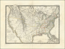
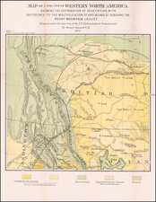
Covens & Mortier edition of the Popple Key Sheet
Fine example of the scarce Covens & Mortier edition of Henry Popple's Key Sheet.
Henry Popple worked with the Board of Trade & Plantations in 1727, during a period when boundary disputes in the colonies began to accelerate the need for detailed maps. In 1730, the Board began requesting detailed maps of the entirety of the provinces and contiguous French and Spanish Dominions. Popple issued an announcement for the map in 1731, but did not complete work until 1733. The map was not a commercial success and did not sell well until after William Henry Toms and Samuel Harding took over publication in 1739. With the outbreak of the War of Jenkin's Ear, the map saw its commercial successes soar. In 1746, the rights to the map passed to Willdey and Austen, who published it until Austen's death in 1750.
This is the Covens & Mortier edition of Popple's Key Sheet, based upon the first edition of Popple's key sheet, with no place names appearing between Havana and C.S. Antonio, as identified by Babinski.
The map includes 4 views (New York Harbour, Québec, México City and Niagara Falls) and 17 Harbour Plans. The cartographic significance of Popple's map is the subject matter of a number of books and articles. In short, it is the most important map of the Colonies to date and an essential map for collectors.
Covens & Mortier was one of the largest and most successful publishing firms in Dutch history and continued in business for over a century. Pierre Mortier the Elder (1661-1711) had obtained a privilege in 1690 to distribute the works of French geographers in the Netherlands. After his widow continued the business for several years, Cornelis (1699-1783) took over in 1719.
In 1721, Mortier forged a partnership with Johannes Covens (1697-1774), who had recently married Cornelis’ sister. They published under the joint name of Covens & Mortier. In 1774, upon the death of his father, Johannes Covens II (1722-1794) took over his father’s share. In 1778, the company changed its name to J. Covens & Zoon, or J. Covens & Son.
Covens II’s son, Cornelis (1764-1825), later inherited the business and brought Petrus Mortier IV back into the fold. Petrus was the great-grandson of Petrus Mortier I. From 1794, the business was called Mortier, Covens & Zoon, or Mortier, Covens, & Son.
The business specialized in publishing French geographers including Deslisle, Jaillot, Janssonius, and Sanson. They also published atlases, for example a 1725 reissue of Frederik de Wit’s Atlas Major and an atlas, with additions, from the works of Guillaume Delisle. There were also Covens & Mortier pocket atlases and town atlases. The company profited from acquiring plates from other geographers as well. For example, the purchased Pieter van der Aa’s plates in 1730. Finally, they also compiled a few maps in house. At their height, they had the largest collection of geographic prints ever assembled in Amsterdam.