|
||

|

|
|

|
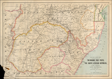
James Wyld's map of South Africa.
An extremely detailed and authoritative mapping of South Africa from 1872, constituting a later edition from James Wyld's series of maps of South Africa that were first issued in 1843. The map reflects the recent discoveries and the shifting political boundaries that characterized the exploration and colonization of South Africa in the mid-19th century.
Numerous internal and external political borders are delineated with hand-color. These borders shift considerably over the course of Wyld's editions, providing a fascinating and authoritative insight into minute historical changes. The printed map includes a key that references similar political developments, including indicating land recently settled by emigrants from the Cape Colony, land "taken from Aboriginal tribes", etc.
Wyld credits Major Sebryn, Lieutenant Sherron, Messrs. Alexander Backhouse, Centlivre Chase, Christopher Moffat, and the MS. of the Missions Evangelique.
The Transvaal Republic (Zuid-Afrikaansche Republiek, in Dutch), is shown in the upper right corner of the map. The ZAR defeated the British in the First Boer War, and was eventually forced to surrender to them in 1902 after the Second Boer War.
Much of the Namibian coast and Kalahari desert is labelled "Sandy Desolate Country", "Sandy Sterile Country", or "Country Unexplored", as it was in the first edition of 30 years prior.
James Wyld
James Wyld (1812-1887), was the Royal Geographer to Queen Victoria and Prince Albert (the prince maintained a great interest in science and cartography), and simply "Royal Geographer to the Queen" after Prince Albert's death in December 1861. Wyld was the official inheritor of the superlative mapmaking business of William Faden (1749-1836). He had almost unparalleled access to official and private archives. And was only really matched by the Arrowsmith mapmakers, namely John Arrowsmith. Wyld's maps are prized as accurate representations of Britain's far-flung colonies in Africa, Australia and New Zealand, and Canada, among others. His maps were consulted by the Cabinet at Whitehall and by colonial officials in places such as Cape Town.
James Wyld Sr. (1790-1836) was a British cartographer and one of Europe’s leading mapmakers. He made many contributions to cartography, including the introduction of lithography into map printing in 1812.
William Faden, another celebrated cartographer, passed down his mapmaking business to Wyld in 1823. The quality and quantity of Faden’s maps, combined with Wyld’s considerable skill, brought Wyld great prestige.
Wyld was named geographer to Kings George IV and William IV, as well as HRH the Duke of York. In 1825, he was elected an Associate of the Institution of Civil Engineers. He was one of the founding members of the Royal Geographical Society in 1830. Also in 1830, his son, James Wyld Jr., took over his publishing house. Wyld Sr. died of overwork on October 14, 1836.
James Wyld Jr. (1812-87) was a renowned cartographer in his own right and he successfully carried on his father’s business. He gained the title of Geographer to the Queen and H.R.H. Prince Albert. Punch (1850) described him in humorous cartographic terms, “If Mr. Wyld’s brain should be ever discovered (we will be bound he has a Map of it inside his hat), we should like to have a peep at it, for we have a suspicion that the two hemispheres must be printed, varnished, and glazed, exactly like a pair of globes.”