|
||

|

|
|

|
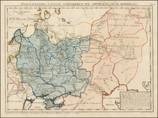
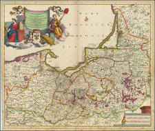
Interesting regional map covering the area north of the Black Sea and extending north to Moscow and Lithuania.
From the 1625-26 edition of Purchas His Pilgrims, one of the seminal early 17th Century English Language travel works. On a 13 x 9 inch sheet with English text, front and back.
Jodocus Hondius the Elder (1563-1612), or Joost de Hondt, was one of the most prominent geographers and engravers of his time. His work did much to establish Amsterdam as the center of cartographic publishing in the seventeenth century. Born in Wakken but raised in Ghent, the young Jodocus worked as an engraver, instrument maker, and globe maker.
Hondius moved to London in 1584, fleeing religious persecution in Flanders. There, he worked for Richard Hakluyt and Edward Wright, among others. Hondius also engraved the globe gores for Emery Molyneux’s pair of globes in 1592; Wright plotted the coastlines. His engraving and nautical painting skills introduced him to an elite group of geographic knowledge seekers and producers, including the navigators Drake, Thomas Cavendish, and Walter Raleigh, as well as engravers like Theodor De Bry and Augustine Ryther. This network gave Hondius access to manuscript charts and descriptions which he then translated into engraved maps.
In 1593 Hondius returned to Amsterdam, where he lived for the rest of his life. Hondius worked in partnership with Cornelis Claesz, a publisher, and maintained his ties to contacts in Europe and England. For example, from 1605 to 1610, Hondius engraved the plates for John Speed’s Theatre of the Empire of Great Britaine.
One of Hondius’ most successful commercial ventures was the reprinting of Mercator’s atlas. When he acquired the Mercator plates, he added 36 maps, many engraved by him, and released the atlas under Mercator’s name, helping to solidify Mercator’s reputation posthumously. Hondius died in 1612, at only 48 years of age, after which time his son of the same name and another son, Henricus, took over the business, including the reissuing of the Mercator atlas. After 1633, Hondius the Elder’s son-in-law, Johannes Janssonius, was also listed as a co-publisher for the atlas.
Samuel Purchas (bap. 1577-1626) is one of the most famous geographers and editors in English history. His important Hakluytus Posthumus served as a source for subsequent geographers for over a century. Purchas was baptized in Thaxted, Essex in 1577, the sixth of ten children. He attended university at St. John’s College, Cambridge and graduated with a BA in 1597 and an MA in 1600. Highly educated, Purchas dedicated his skills to serving as a clergyman in the Church of England. He was ordained as a deacon in 1598 and as a priest in 1601. After serving in several parishes, he became chaplain to Archbishop George Abbot in ca. 1613, the first of several London appointments. At King James’s College, Chelsea, he wrote his only published sermon.
It was at King James’s College that he also composed much of his master work, Hakluytus Posthumus, or, Purchas his Pilgrimes (1624–5). Purchas called upon his relationship with his famous predecessor in travel editing, Richard Hakluyt. In 1620, Purchas acquired the remaining manuscripts collected by Hakluyt and these form the basis for his own work. When it was published, it took three years to print and was the largest book ever published in England. Purchas not only edited and compiled the travel accounts covering Europe, Asia, Africa, and the Americas, but he added anti-Catholic commentary of his own. He died in 1626, shortly after the volumes appeared.
Purchas is important not only as a source for geographers, but for the maps included in his travel collection. The first edition contained nearly ninety maps, some of which were completed by Jodocus Hondius. Not all the maps were original, but there are nevertheless several highly influential maps. For example, the famous John Smith Map of Virginia featured in Purchas’ work. Purchas also included the Henry Briggs Map of North America, the first map in English to show California as an island, as well as the first map to name Hudson’s Bay and the Hudson River. Additionally, there is the William Alexander Map of the Northeast, which pioneered many new place names; Roe’s map of North India, the earliest English map of Mogul lands; and Saris’ map of China, which shows Korea as a peninsula.