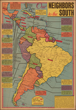
|
||

|

|
|

|
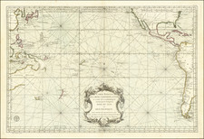
One of the earliest obtainable maps of the Gallapagos Islands, published 150 years prior to Charles Darwin's visit.
Moll's map is the earliest printed ma of the Galapagos Islands.
The map is based upon a manuscipt map drawn by William Ambrosia Cowley. Cowley was sailing master of a pirate ship captained by John Eaton in 1684 when they made landfall at the Galapagos Islands in the Pacific Ocean. Cowley's narrative of the voyage entitled Cowley's Voyage Around the Globe was published in the
Collection of Original Voyages by William Hacke from London in 1699.
In Cowley's manuscript journal he recorded his first observations of the land:
Then we came to an Anchor in a very good Harbour, lying toward the Northernmost end of a fine Island, under the Equinoctial Line: Here being great plenty of Provisions, as Fish, Sea and Land Tortoises, some of which weighed at least 200 Pound weight, which are excellent good Food. Here are also abundance of Fowls, viz. Flemingoes and Turtle Doves; the latter whereof were so tame, that they would often alight upon our Hats and Arms, so as that we could take them alive, they not fearing Man, until such time as some of our Company did fire at them, whereby they were rendered more shy."
Herman Moll (c. 1654-1732) was one of the most important London mapmakers in the first half of the eighteenth century. Moll was probably born in Bremen, Germany, around 1654. He moved to London to escape the Scanian Wars. His earliest work was as an engraver for Moses Pitt on the production of the English Atlas, a failed work which landed Pitt in debtor's prison. Moll also engraved for Sir Jonas Moore, Grenville Collins, John Adair, and the Seller & Price firm. He published his first original maps in the early 1680s and had set up his own shop by the 1690s.
Moll's work quickly helped him become a member of a group which congregated at Jonathan's Coffee House at Number 20 Exchange Alley, Cornhill, where speculators met to trade stock. Moll's circle included the scientist Robert Hooke, the archaeologist William Stuckley, the authors Jonathan Swift and Daniel Defoe, and the intellectually-gifted pirates William Dampier, Woodes Rogers and William Hacke. From these contacts, Moll gained a great deal of privileged information that was included in his maps.
Over the course of his career, he published dozens of geographies, atlases, and histories, not to mention numerous sheet maps. His most famous works are Atlas Geographus, a monthly magazine that ran from 1708 to 1717, and The World Described (1715-54). He also frequently made maps for books, including those of Dampier’s publications and Swift’s Gulliver’s Travels. Moll died in 1732. It is likely that his plates passed to another contemporary, Thomas Bowles, after this death.
![[The Rarest State] Americae Sive Novi Orbis Nova Descriptio](https://storage.googleapis.com/raremaps/img/small/80521.jpg)