


|
||

|

|
|

|
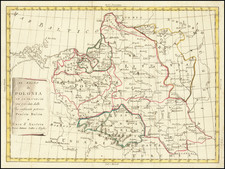
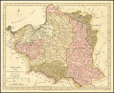
Detailed map of Poland, published between the two World Wars.
The map notes the Scenes of World War I Battles, the Free City of Danzig (in Yellow), and an uncolored area in Poland noting a plebiscite area.
Upper Silesia Plebiscite
The uncolored area in the southwest shows the area of the Upper Silesia plebiscite, as mandated by the Versailles Treaty and carried out in March 1921 to determine a section of the border between Weimar Germany and Poland. The region was ethnically mixed with both Germans and Poles. The period of the plebiscite campaign and interallied occupation was marked by violence. There were two Polish uprisings, and German volunteer paramilitary units came to the region as well.
The area was policed by French, British, and Italian troops, and overseen by an Interallied Commission. The Allies planned on a partition the region, but a Polish uprising took control of over half the area. The Germans responded with volunteer paramilitary units from all over Germany, which fought the Polish units. In the end, after renewed Allied military intervention, the final position of the opposing forces became, roughly, the new border. The decision was handed over to the League of Nations, which confirmed this border, and Poland received roughly one third of the plebiscite zone by area, including the greater part of the industrial region.
The Free City of Danzig
The Free City of Danzig existed from 1920 to 1939. The area consist of the Baltic Sea port of Danzig (now Gdańsk, Poland) and nearly 200 towns in the surrounding areas. It was created on November 15, 1920, in accordance with the terms the 1919 Treaty of Versailles after the end of World War I. The Free City had been primarily inhabited by ethnic Germans. As the Treaty stated, the region was to remain separated from post-World War I Germany (the Weimar Republic) and from the newly independent nation of the Second Polish Republic ("interwar Poland"), but it was not an independent state. The Free City was under League of Nations protection and put into a binding customs union with Poland.
Poland was given full rights to develop and maintain transportation, communication, and port facilities in the city. The Free City was created in order to give Poland access to a well-sized seaport. In 1933, the City's government was taken over by the local Nazi Party, which suppressed the democratic opposition. Due to anti-Semitic persecution and oppression, many Jews fled. After the German invasion of Poland in 1939, the Nazis abolished the Free City and incorporated the area into the newly formed Reichsgau of Danzig-West Prussia.
During the city's conquest by the Soviet Army in the early months of 1945, many citizens fled or were killed. After the war, many surviving ethnic Germans were expelled and deported to the West when members of the pre-war Polish minority started returning. The city subsequently became part of Poland, as a consequence of the Potsdam Agreement.
![[Holy Roman Empire] A Newe Mape of Germany Newly Augmented by Iohn Speed Ano Dom: 1626](https://storage.googleapis.com/raremaps/img/small/67323.jpg)
![[Kiev Region] Li Palatinati di Braclaw e Kiowia Tratta dell' Atlante Polacco del Sigr Rizzi Zanoni . . . 1781](https://storage.googleapis.com/raremaps/img/small/78390.jpg)
![[ Tribal Germany ] Germania Antiqua in IV magnos populaos in minores et minimos distincta et Regiones Danubium…1785](https://storage.googleapis.com/raremaps/img/small/97958.jpg)