


|
||

|

|
|

|
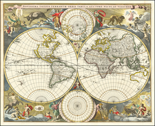
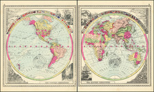
Rare English Sea Chart of the World on the Wright-Molyneux Projection, Published to Promote the Expedition of John Wood in Search of the Northeast Passage.
Remarkable early English Sea Chart of the World, published by Robert Morden & William Berry in London, prepared prior to the attempt by Captain John Wood to locate the Northeast Passage, the first such attempt by an Englishman in 100 years.
It is quite possible that this map was prepared specifically for Wood's voyage. As such it was almost certainly published sometime between mid 1675 and March 1676, when the voyage set sail. In her study of the map, Jeanette Black notes in the Blathwayt Atlas Commentary:
One of the geographical features could not have been included before 1674. The outline of the island of Nova Zemba (now Nova Zemlya) in the polar inset at the upper left of the map follows closely the concept delineated in a small map published in the Royal Society's Philosophical Transactions for March of that year.
The most likely moment for the publication of the map . . . was in the early months of 1676, when he was preparing to go on his well-publicized voyage for the purpose of discovering a northeast passage to Asia. The outlines of the polar inset correspond to the ideas he had before setting out, and there is no hint of his track or of place names derived from his voyage. If the map was published in the Spring of 1676, it is possible that one of the entires in the Plantations Office accounts refers to it . . . A statement of expense up to 24 June 1676 contains an item of two shillings for "The World in two Sheets." The price indicates and uncolored copy, because the usual charge for an engravced map was a shilling a sheet, with an extra shilling a sheet for coloring. No orther two-sheet World map is recorded as published in England during this period. World maps were more likely to be printed on a single sheet, except for a few very large productions on several sheets, most of which are not known in surviving examples.
There is a second state of this map, readily distinguishable from the first by the presence of the names "Pensilvania" and "N. Iersy." . .
The is one of the earliest maps of a series of representations of Nova Zemlya as a peninsula by English mapmakers between the years 1674 and 1680. Woods, in several written statements, references his own manuscript "draught", for which the location is unknown and presumed lost.
The map's depiction of the Northeastern Coastline of Asia is of note, as Wood eschews an attempt at certainty or the adoption of the conjectural coastal features favored by French and Dutch mapmakers, simply leaving a faint and tentative line for the coastline for most of the distance between Japan and the Arctic Circle.
Of additional note, this second edition of the map is quite likely the earliest printed map to name Pennsylvania.
John Wood
John Wood was a naval officer who had sailed with Sir John Narborough to the Straits of Magellan in 1671. He was known as an excellent navigfator with a special interest in studying the behavior of the compass in high latitudes. Following the failure of the third Frobisher expedition (1578) and the Pet and Jackman expedition (1580) to discover the Northeast Passage, the focus of English Explorers turned to the search for the Northwest Passage, and there were no further English sponsored attempts to locate a Northeast Passage until 1676. Beginning with notices which appeared in the Transactions of the Royal Society in 1675, Captain John Wood led an effort to revive interest in the Northeast Passage. Wood compiled a statement and "polar draught," showing the discoveries of earlier navigators, and presented it to King Charles II, who in turn granted 2 ships to Wood for the expedition.
In 1676, Wood undertook what Helen Wallis has described as "his disastrous and ill-conceived polar voyage." (England's Search for the Northern Passages in the Sixteenth and Early Seventeen Centuries, Arctic Vol.37, No. 4, December 1984, p 457). Wood's voyage to Nova Zembla receives little attention in modern times. One of the most noteworthy features of the expedition, was the inclusion of Grenville Collins, one of England's first great hydrographers, on the expedition.
The Admiralty appointed Collins as master of the Speedwell in 1676. Captain John Wood commanded that ship, and intended to reach Japan by the then supposed North-East passage. Wood had served with Collins aboard the Sweepstake during Narborough's expedition, and held Collins in high regard. The Speedwell was wrecked off Novaya Zemlya, but the crew was rescued and returned aboard their consort ship, Prosperous. Collins's journal of the voyage brought him to the attention of King Charles II.
With the exception of the Russians, no further attempts were made to find the Northeast Passage in the 17th or 18th Centuries, except by the Russians.
Rarity
The map is exceptionally rare on the market. The last example to appear in a dealer catalog was in 1975 (Weinreb & Douwma, Catalog 16). Shirley located 2 examples of State 1 (British Library and Clements Library) and 1 example of State 2 (National Maritime Museum, bound into an atlas presented to King James II). The John Carter Brown owns the Western half of the map in the Blathwayt Atlas.
Robert Morden (d. 1703) was a British map and globe maker. Little is known about his early life, although he was most likely apprenticed to Joseph Moxon. By 1671, Morden was working from the sign of the Atlas on Cornhill, the same address out of which Moxon had previously worked. Most famous for his English county maps, his geography texts, and his wall maps, Morden entered into many partnerships during his career, usually to finance larger publishing projects.
![World [Rand, McNally & Company's Indexed Atlas of the World]](https://storage.googleapis.com/raremaps/img/small/100314.jpg)