This item has been sold, but you can enter your email address to be notified if another example becomes available.


|
||

|

|
|

|
Stock# 46722
Description
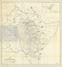
Interesting early map of part of Dakota Territory.
The map is focused on the township surveys and the various Indian reserves along the Missouri River, including the Yankton Reserve, Ft. Randall Military Reserve and Ponka Reserve, along with an Indian Reservation in the Northwest.
Nice early regional map.
Condition Description
Usual toning at folds. Narrow left margin, with partial loss of neat line. Minor fold breaks, reinforced on verso.
![[Uncaptioned image of two figures seated in front of a tipi, mounted albumen print]](https://storage.googleapis.com/raremaps/img/small/78744.jpg)

![[ Transatlantic Cable and Transcontinental Railroad ] Kaart van de eerste (Engelsche en Fransche) telegraaf-kabels tusschen Europa en Amerika (and) Kaart van den Union Pacific-Spoorweg van Chicago naar San-Francisco](https://storage.googleapis.com/raremaps/img/small/105775.jpg)