|
||

|

|
|

|
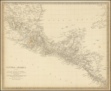
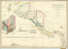
Fine example of the second edition of this finely detailed map of Central America, prepared by John Baily, who served as a surveyor of Nicaragua and was an early proponent of a canal across Central America, published in London by Trelawney Saunders.
First issued in 1850, the map indicates that it has been revised to include surveys by:
- The British Admiralty
- Giovanni Battista Agostino Codazzi (Panama & Costa Rica)
- Gaetano Moro (Isthums of Tehuantepec)
- Colonel John Augustus Lloyd (Isthmus of Panama)
- Napoleon Garella (Panama)
- Hughes
- Childs
- Details from the Railway Surveys in Honduras furnished by E.G. Squier, former US Charge d'Affaires to the Republic of Central America.
John Baily was an Englishman who lived for many years in Central America. He was employed in 1837-38 by the government of Nicaragua to survey a potential canal route from the Caribbean Sea to the Pacific Ocean. In 1850, Baily published this book and a separate map of Central America (the present map), which showed four proposed routes for a canal between the Atlantic and Pacific Oceans. Baily was convinced of the "remarkable capacity for colonization" of the Central American countries. Baily compared agricultural conditions in Central America to those in southern Texas and argued that European farmers who settled in the region and worked hard would prosper and "prepare a handsome inheritance for their posterity."
This map includes the address 55 Charing Cross for Stanford's. They moved to that locale in 1874.