


|
||

|

|
|

|
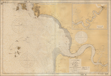
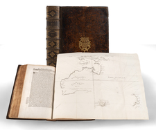
Finely engraved plan of the Dutch controlled fortified harbor and town of Malacca City, from Jacques Nicolas Bellin's Le Petit Atlas Maritime Recueti de Cartes et Plans des Quatre Parlies du Monde en Cinq Volumes, first published in Paris in 1764.
Originally Malacca was ruled by early Malay sultanates. Before the arrival of the first Sultan, Malacca was a fishing village inhabited by local Malays known as Orang Laut. Malacca was founded by Parameswara, also known as Iskandar Shah or Sri Majara, the last Raja of Temasek (present day Singapore) following a Majapahit attack in 1377. He found his way to Malacca around 1400 where he found a good port-it was accessible in all seasons and on the strategically located narrowest point of the Malacca Straits. In collaboration with allies from the sea-people (orang laut), the wandering proto-Malay privateers of the Straits, he established Malacca as an international port by compelling passing ships to call there, and establishing fair and reliable facilities for warehousing and trade.
Because of its strategic location, Malacca was an important stopping point for Zheng He's fleet. To enhance relations, Hang Li Po, according to local folklore a daughter of the Ming Emperor of China, arrived in Malacca, accompanied by 500 attendants, to marry Sultan Manshur Shah who reigned from 1456 until 1477.
In April 1511, Alfonso de Albuquerque set sail from Goa to Malacca with a force of seventeen or eighteen ships, taking Malacca in August 1511. The Portugese controlled Malacca for the next 130 years.
The Dutch launched several attacks on the Portuguese colony during the first four decades of the seventeenth century. The first attack took place in 1606 under the command of Dutch Admiral Cornelis Matelief de Jonge, who laid siege to the town with the help of his Johor allies. He engaged the Portuguese armada which had been sent from Goa to offer armed relief to the besieged port. In 1641, the Dutch defeated the Portuguese in an effort to capture Malacca, with the help of the Sultan of Johore. The Dutch ruled Malacca from 1641 to 1798.
Jacques Nicolas Bellin
Jacques Nicolas Bellin (1703-1772) is among the most important mapmakers of the 18th Century.
In 1721, at age 18, he was appointed hydrographer (chief cartographer) to the French Navy. In August 1741, he became the first Ingénieur de la Marine of the Depot des cartes et plans de la Marine (the French Hydrographical Office) and was named Official Hydrographer of the French King.
During his term as Official Hydrographer, the Depot was the single most active center for the production of sea charts and maps, including a large folio format sea-chart of France, the Neptune Francois. He also produced a number of sea-atlases of the world, e.g., the Atlas Maritime and the Hydrographie Francaise. These gained fame, distinction and respect all over Europe and were republished throughout the 18th and even in the succeeding century.
Bellin also came out with smaller format maps such as the 1764 Petit Atlas Maritime, containing 580 finely detailed charts. He also contributed many of the maps for Bellin, to the 15 volume Histoire Generale des Voyages of Antoine François Prévost or simply known l'Abbe Prevost.
Bellin set a very high standard of workmanship and accuracy, thus gaining for France a leading role in European cartography and geography. Many of his maps were copied by other mapmakers of Europe.
Jacques-Nicolas Bellin (1703-1772) was among the most important mapmakers of the eighteenth century. In 1721, at only the age of 18, he was appointed Hydrographer to the French Navy. In August 1741, he became the first Ingénieur de la Marine of the Dépôt des cartes et plans de la Marine (the French Hydrographic Office) and was named Official Hydrographer of the French King.
During his term as Official Hydrographer, the Dépôt was the one of the most active centers for the production of sea charts and maps in Europe. Their output included a folio-format sea atlas of France, the Neptune Francois. He also produced a number of sea atlases of the world, including the Atlas Maritime and the Hydrographie Francaise. These gained fame and distinction all over Europe and were republished throughout the eighteenth and even in the nineteenth century.
Bellin also produced smaller format maps such as the 1764 Petit Atlas Maritime, containing 580 finely-detailed charts. He also contributed a number of maps for the 15-volume Histoire Generale des Voyages of Antoine François Prévost.
Bellin set a very high standard of workmanship and accuracy, cementing France's leading role in European cartography and geography during this period. Many of his maps were copied by other mapmakers across the continent.
![Asia Secunda Pars Terrae in Forma Pegasi [Asia in the Form of Pegasus]](https://storage.googleapis.com/raremaps/img/small/94173.jpg)