|
||

|

|
|

|
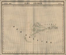
Later edition of this important early sea chart, which accompanied the Protocol of Agreement between Her Majesty and the United States of America, defining the Boundary Line through the Canal de Haro, in accordance with the Award of the Emperor of Germany, of October 21, 1872, which was signed in Washington on March 10, 1873.
The boundary dispute between Britain and the US regarding the Strait of Juan De Fuca, through to Roberts Point was resolved by submission of the matter to the Emperor of Germany. The Protocol and this accompanying map reflect the results of his decision and includes a blue and red line showing the final boundary decision. The map is signed by Edward Thornton, Hamilton Fish and James Prevost.
This example of the map was re-issued by the US Government in 1895.
![[ Missionary Map ] Canada Carte Indiquant Les Limites Des Dioceses, etc. Catholiques Romains Par G. Baillairge Ex-depute-ministre des Treavaux Publics de Canada 1893.](https://storage.googleapis.com/raremaps/img/small/37899.jpg)