|
||

|

|
|

|
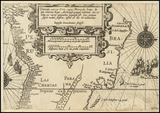
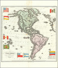
One of the earliest Maps To Incorporate Information From Lewis & Clark
While the map covers all of America, it is truly remarkable for its coverage of the Transmississippi West. It also provides a nice early depiction of the Course of the Florida (Gulf) Stream.
The map depicts "Course of the R. Missouri extending to former conjectures", along with a remarkable depiction of the Pacific Northwest, on level of detail and accuracy not previously seen on any printed map.
The map clearly draws upon Soulard, Arrowsmith and Lewis & Clark for its sources.
Warren Heckrotte points out some geographically significant features:
The representation of the Missouri is interesting. Up to the great bend he seems to have followed Arrowsmith. And beyond that he shows Arrowsmith's dotted line representation of the Missouri to the Rockies, which Laurie & Whittle characterize as 'former conjectures.' They then show in solid line the Missouri proceeding west identified as 'River Missouri of Capt Lewis.' But to this they have added Soulard's representation of the Missouri with the great northern loop. Beyond that they have added the Gallatin, Madison and Jefferson as on the map in the 1809 Lewis and Clark and the map with the 1810 French Gass."
The map is extremely rare. We note only 1 other example in the Canadian National Archives (Quebec).
Provenance. Butterfield & Butterfield, December 16, 1996; Warren Heckrotte Collection, PBA Galleries March 2016.
James Whittle (1757-1818) was a British engraver and map printer. Whittle was employed by Robert Sayer (ca. 1725-1794). Together with Robert Laurie (1755?-1836), he took on Sayer’s business when the older man died in 1794. The two traded together as Laurie & Whittle until 1812, when Laurie retired. They had specialized in sea charts and maritime atlases. Whittle then partnered with Laurie’s son, Richard Holmes Laurie, until he died in 1818.
Robert Laurie (1755?-1836) was a British engraver and printseller who specialized in engraving portraits and in publishing maritime charts. His family originated in Dumfriesshire. As a young man he came to London and was apprenticed to Robert Sayer (ca. 1724-1794) in 1770. He received several awards in the 1770s for his mezzotint engraving and printing. He worked for Sayer as apprentice, assistant, and later partner.
In 1794, when Sayer died, Laurie took on his business alongside James Whittle, his fellow Sayer employee. Laurie managed the business and ceased almost all engraving. Instead, he oversaw the prodigious output of printed materials, especially sea charts and maritime atlases. He retired in 1812.
Laurie’s son, Richard Holmes Laurie, took over his part of the business and continued in business as Whittle & Laurie, rather than the previous Laurie & Whittle. Whittle died in 1818, leaving Richard as the sold proprietor of the business. Robert died in 1836 in Hertfordshire.
![[Portrait] L'Amerique.](https://storage.googleapis.com/raremaps/img/small/79745.jpg)