|
||

|

|
|

|
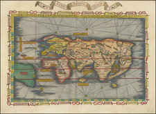
A Superb 17th Century Wall Map of the World, after Joannes Blaeu and Frederick De Wit
Striking example of one of the most iconic world map images of the 17th Century.
Overview
This is the Giuseppe Longhi edition of Frederick de Wit's 12-sheet map of the world. Longhi's map is part of an important lineage of Dutch wall maps, beginning with Joannes Blaeu's monumental world map of 1648. Frederick De Wit, in turn used Blaeu's map as the basis for his large production of 1660.
The map is embellished in the four corners by allegorical figures representing the four continents, their flora and fauna. The remaining areas around the maprs bear elaborate celestial charts and scientific models of the universe, the top center image likely based upon Andreas Cellarius's monumental work of 1660. In the oceans, numerous sailing ships are shown a number of which are engaged in battles, reflective of the the Dutch origins of this map and the remarkable reach of the Dutch mariners and traders in the middle of the 17th Century.
Giuseppe Longhi
The present map was published in Bologna, Italy about 20 years after the first De Wit edition, and it is typically dated circa 1680. Giuseppe Longhi of Bologna flourished in 1660s to 1680s. Longhi's engraved works are all very rare today and virtually nothing had been written about him and very little is known about his biography. He is perhaps best known for his magnificent 12-sheet map of Italy (after Matthaeus Greuter), and a number of multi-sheet city views, including Prague, Genoa, Venice, Naples and Bologna many of which are known in only a few examples. In 2011, we sold the only known example of Longhi's plan of Vienna and in 2016 we sold the only known example of Longhi's 4 sheet view of Cracow.
Longhi was likely associated with Pietro Todeschi, who was active in Bologna from 1670 to 1690. We have been unable to locate any other cartographic works by Longhi.
Cartographic Content & Lineage
The geography of the Longhi world map follows that of the 1648 Blaeu map very closely. Blaeu's map was the first to record the discoveries of Abel Jansz Tasman in Tasmania, New Zealand, and northern Australia, which he undertook between 1642 and 1644. The information gathered by Tasman is present in the Longhi.
Whereas Blaeu had done away with the speculative antarctic continent, Longhi brings it back in the form of a large, undulating Terra Magellanica Australis Incognita. Similarly, Longhi adds the tentative Terra Jesso, forming a bridge between Asia and North America - very roughly approximating Alaska.
California is shown as an island. The Great Lakes are very loosely articulated as a single large inland sea. Korea is shown as a peninsula, rather than an island, as in the first state of the Blaeu map, one of the earliest maps to make this transition, following Martino's mapping of China.
Interestingly, the Blaeu world map of 1648 is often taken as the reference for Ferdinand Verbiest's 1674 world map. Yet Verbiest's landmark map shares more with the Longhi version, perhaps because it was derived from later states of the Blaeu.
There is another Italian version of the Blaeu-De Wit, which was issued in Rome by Giovanni de Rossi. There is some confusion as to whether this map pre- or post-dates the De Rossi world map. The Longhi and the De Rossi maps appear to be printed from the same plates, albeit slightly altered in the decorative details. The Rossi map is known from a single example that was offered at Sotheby's in 1980.
Wall Maps From the 17th Century
The present map is an especially fine example of the grand genre of wall or parlor maps that enjoyed an iconic place in 17th and early 18th century Europe. Prior to the 17th Century, Wall maps were painted on the walls of the Vatican and Palazzo's of the Medicis and other powerful Italian families by artists such as Ignatio Danti. A few oversized wall maps were printed on paper, of which only a few few from the 16h Century survive.
The Vatican Map Hall: http://mapdesign.icaci.org/2014/11/mapcarte-319365-the-gallery-of-maps-by-ignazio-danti-1550-1583/
By the opening of the 17th Century, these remarkable large productions were gaining currency as objects of art and worldly sophistication. Large, highly decorative and expensive productions, they were considered to be the ultimate signs of wealth and intellectual sophistication. Martin Bruckner notes:
During the 17th Century, the display of wall maps became more common, moving from palaces of the politcal elite into the homes of the Italian, Dutch and English nouveau riches . . . Paintings, such as Jan Vermeers's Officer and Laughing Girl (1658) and The Art of Painting (1666), illustrate in great detail how oversized wall maps were integrated into material decor of merchant homes. Shown next to tapestries, mirrors, and framed paintings, canvas-backed maps suspended on rollers were the only large printed goods to join decorative objects specifcially intended for vertical display afforded by architectural interiors.
As noted by the Osher Library, Smith Center for Cartographic Education in its on Line exhibition:
The development of printing greatly increased the availability of wall maps. Printed from multiple woodblocks or engraved copper plates, individual sheets were joined to form wall maps and were then mounted for framing or backed with cloth and attached to rods for hanging. Such maps reached the peak of their popularity in the Netherlands in the sixteenth and seventeenth centuries, a time of expanding colonial empire and great interest in exploration. Appreciated as works of art and as symbols of success, they found great favor as wall hangings in public buildings, places of business, and homes of affluent merchants and burghers. . . .
The number of surviving wall maps is small because many were destroyed by exposure to light, variations of temperature and humidity, pollution, handling, and general wear and tear. A few have been preserved in good condition by being bound in giant atlases . . .
Click here to see a Vermeer with wall map: https://en.wikipedia.org/wiki/The_Art_of_Painting
Rarity
As with all 17th Century wall maps of this size, the survival rare is very low. This is only the second example of the map to appear on the market in the past 30 years.
Other examples of this map are held in the Newberry Library; the Rotterdam Maritime Museum, and the Instituto Geografico Militare, Florence. An example of the map is known to have been sold in London in 2014, lacking the decorative borders.
De Wit (1629 ca.-1706) was a mapmaker and mapseller who was born in Gouda but who worked and died in Amsterdam. He moved to the city in 1648, where he opened a printing operation under the name of The Three Crabs; later, he changed the name of his shop to The White Chart. From the 1660s onward, he published atlases with a variety of maps; he is best known for these atlases and his Dutch town maps. After Frederik’s death in 1706, his wife Maria ran the shop for four years before selling it. Their son, Franciscus, was a stockfish merchant and had no interest in the map shop. At the auction to liquidate the de Wit stock, most of the plates went to Pieter Mortier, whose firm eventually became Covens & Mortier, one of the biggest cartography houses of the eighteenth century.
![World [Rand, McNally & Company's Indexed Atlas of the World]](https://storage.googleapis.com/raremaps/img/small/100314.jpg)
![Hemisphere Septentrional du Globe Terrestre Veu en concave l'oeil estant au Pole AntArctique . . . 1696 [and] Hemisphere Superieur du Globe Terreste pour l'Horizon de Paris Veu en convexe l'oeil etant pose au zenith et a distance infinie du plan de projection . . . 1697](https://storage.googleapis.com/raremaps/img/small/85541.jpg)