|
||

|

|
|

|
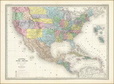
The Adams Onis Treaty Edition of The Most Important Map of the United States Published in the 19th Century
John Melish's map of the United States is the single most important and influential map of America published in the 19th Century and is rivaled only by John Mitchell's map of North America in 1755 as the single most influential map in American History.
This edition of the map is the first to show Alabama Territory, and includes extensive revisions in Illinois Territory.
Heckrotte notes this as the second 1818 state, with extensive revisions in Illinois Territory, Indiana Territory and the newly formed Alabama Territory.
Improved to the 1st of January 1818, and relates that "This is the Wrather copy (according to W. Howell) noted by Ristow in his study of the Melish map of the United States. One of the 1818 states was used in the United States - Spanish negotiations to settle the boundary between U.S. and Spanish possessions in the west."
Among the most important changes in this state of the map are the addition for the first time, of 5 Land Districts on the West Side of the Mississippi River:
- St. Louis District
- Lawrence District
- Howard District
- Cape Girardeau District
- Arkansas District
These districts are holdovers from the formation of Louisiana Territory and thereafter. Originally Louisiana Territory had five subdivisions: St. Louis District, St. Charles District, Ste. Genevieve District, Cape Girardeau District , and New Madrid District. In 1806, the territorial legislature created Arkansas District from lands ceded by the Osage Nation. Howard District was created by an Act of Congress dated Febraury 17, 1818, again reflecting lands obtained from Plains Indians following the creation of the Indian Boundary Line of 1816. The Lawrence District would seem to have been established in 1818 also, although we have located no definitive information on its creation.
The present map is also of tremendous importance for its revisions in Illinois Territory, including:
- The Illinois-Indiana Boundary has been adjusted further west.
- The Upper Course of the Illinois River is completely revised, with 9 place names removed and 6 names added for the first time along the River.
- The details along the Mississippi River in western Illinois are significantly revised, with 7 names removed and 2 new names added.
- The Little Wabash River is named for the first time.
- The course of the Wabash is significantly revised.
Described by Thomas Jefferson as a luminous view of the comparative possessions of different powers in our America, Melish's map, first issued in 1816, was the first indigenous attempt to map the United States from coast to coast and synthesized the works of Lewis & Clark, Humboldt, Pike, Arrowsmith and others for the first time, in a single large format coast-to-coast mapping of the United States.
Much as Mitchell's map influenced boundary disputes and treaties in North America for nearly a century after its publication, the Melish map similarly became the essential source map for the 19th Century. It has been described by several commentators as the visual embodiment of Manifest Destiny to an American public searching for a graphic depiction of America's territorial acquisitions from coast-to-coast in the early 19th Century. Following the Louisiana Purchase, Americans turned their attention westward to the great expanse from the Mississippi River to the Pacific Ocean. While the explorations of Lewis & Clark and Zebullon Pike provided early regional snapshots of previously unknown regions in the West, it was left to Melish to tie together these works, along with Arrowsmith's map of Mexico and other available sources, into the first systematic and comprehensive map of the United States.
Prior to his map of the United States, Melish had produced a number of other highly acclaimed regional maps like his rare Military & Topographical Atlas of the United States. However, this map of the United States would become his masterwork, ultimately reissued in 25 known states of the map between 1816 and 1823.
The most notable advance in the later states of the map is the addition of an extra plate at the bottom of the map, which provided coverage of Cuba, Jamaica, the Virgin Islands and the remainder of the Gulf Coast and the Yucatan, to the map. The map, in its various editions, faithfully recorded the changing geography of the US, as various boundary disputes, treaties and explorations extended both the geographical territory of the US and a young nation's knowledge of its own territory. As noted below, the Adams-Onis Treaty of 1819 was laid out on a copy of this 1818 edition of the map.
Adams-Onis Treaty -- Texas History--The Red River Boundary Controversy
The 1818 edition of the map was the map used in the Adams-Onis Treat of 1819, establishing the boundary along what would become the border between Texas and the United States, moreover, an error in the map led to a boundary controversy which lasted until the end of the Century.
The Red River boundary controversy started when the United States purchased the Territory of Louisiana from France in 1803. Spain and the United States feuded over the exact boundary between Louisiana and New Spain. The Adams-Onís Treaty of 1819 used this 1818 edition of the Melish to establish the Red River as the southwestern boundary between the two countries. Later, the Red River served as an international boundary between the United States and Mexico and, after the Texas Revolution, with the Republic of Texas. Unfortunately, the 100th Meridian on the Melish map was marked 90 miles east of its true location, and the Red River forked about 50 miles east of the 100th Meridian. Texas claimed the land south of the North Fork, and the United States claimed the land north of the South Fork.
After Texas joined the United States in 1845, new doubts arose over the legal boundary line when in 1852 Capt. Randolph Marcy discovered the North Fork of the Red River. Texas claimed the area called Greer County between the North Fork and the main branch. In 1867, Federal treaties further complicated the issue by creating a reservation with a southern border, "north of the middle of the main channel" of the Red River, for the Kiowa, Comanche, and Apache. The "Greer County War" began. In 1894 the dispute landed before the Supreme Court as the United States v. Texas. In the background hovered the Organic Act of 1890, which created the Territory of Oklahoma.
After hearing all the testimony and after examining all the documents, the Court held that the central issue was to determine what the negotiators of the Treaty of 1819 had believed the boundary to be at the time they presented the treaty for ratification by both national governments. In the end, the court ruled the old map of John Melish was the central piece of evidence, and the map showed the southern branch to be the understood boundary.
The exact language of Article 3 of the Adams-Onis Treaty provided:
ARTICLE 3
The Boundary Line between the two Countries, West of the Mississippi, shall begin on the Gulf of Mexico, at the mouth of the River Sabine in the Sea, continuing North, along the Western Bank of that River, to the 32d degree of Latitude; thence by a Line due North to the degree of Latitude, where it strikes the Rio Roxo of Nachitoches, or Red-River, then following the course of the Rio-Roxo Westward to the degree of Longitude, 100 West from London and 23 from Washington, then crossing the said Red-River, and running thence by a Line due North to the River Arkansas, thence, following the Course of the Southern bank of the Arkansas to its source in Latitude, 42. North and thence by that parallel of Latitude to the South-Sea. The whole being as laid down in Melish's Map of the United States, published at Philadelphia, improved to the first of January 1818 . But if the Source of the Arkansas River shall be found to fall North or South of Latitude 42, then the Line shall run from the said Source due South or North, as the case may be, till it meets the said Parallel of Latitude 42, and thence along the said Parallel to the South Sea: all the Islands in the Sabine and the Said Red and Arkansas Rivers, throughout the Course thus described, to belong to the United States; but the use of the Waters and the navigation of the Sabine to the Sea, and of the said Rivers, Roxo and Arkansas, throughout the extent of the said Boundary, on their respective Banks, shall be common to the respective inhabitants of both Nations. The Two High Contracting Parties agree to cede and renounce all their rights, claims and pretensions to the Territories described by the said Line: that is to say.-The United States hereby cede to His Catholic Majesty, and renounce forever, all their rights, claims, and pretensions to the Territories lying West and South of the above described Line; and, in like manner, His Catholic Majesty cedes to the said United States, all his rights, claims, and pretensions to any Territories, East and North of the said Line, and, for himself, his heirs and successors, renounces all claim to the said Territories forever.
Melish reportedly released only 100 copies of each edition. Because of the map's size and its use as a official source, relatively few copies have survived.
Provenance: Warren Heckrotte -- John Howell Books (1972) -- Jack Wrather (Produced The Lone Ranger, Sergeant Preston of the Yukon, and Lassie television series in the 1950s -- Married to actress Bonita Granville)
John Melish (1771-1822) was the most prominent American mapmaker of his generation, even though his cartographic career lasted only a decade. Melish was born in Scotland; he moved to the West Indies in 1798 and then to the United States in 1806. By 1811, he had settled in Philadelphia and published Travels through the United States of America, in the years 1806 & 1807, and 1809, 1810, & 1811, which was richly illustrated with maps.
Melish created several regional maps of the highest quality, as well as the Military & Topographical Atlas of the United States (Philadelphia, 1813, expanded 1815). The latter work is widely considered to be the finest cartographic publication to come out of the War of 1812.
By far his best-known work is his monumental map of the United States of 1816, Map of the United States with the contiguous British and Spanish Possessions. He began working on the map in 1815 and sent it to Thomas Jefferson for comment in 1816. Jefferson enthusiastically reviewed the map and returned it with his edits. Jefferson later hung an example of the map in the Entrance Hall of Monticello and sent it to associates in Europe.
Melish’s finished product was the first map of the United States to extend to the Pacific Ocean. After its publication in 1816, Melish ensured the map was as up-to-date as possible; it was reissued in 25 known states published between 1816 and 1823. The map captured the then rapidly changing geography of the United States, as well as various boundary disputes, treaties, and expansion.