|
||

|

|
|

|
Superb Manuscript Chart of the Lower Mississippi Specially Prepared for Alexander Hamilton at the time of the Louisiana Purchase (The "McGrudar Chart").
The McGrudar Chart of the Lower Mississippi River is a manuscript map of exceptional historical importance. Although mentioned in the papers of Alexander Hamilton, the chart was presumed lost until its chance rediscovery in early 2016. Almost certainly drawn in the Fall of 1803 for Abraham Ellery for transmission to Alexander Hamilton, and covering approximately 350 miles from Natchez to New Orleans, the McGrudard Chart is perhaps the sole surviving visual artifact of Alexander Hamilton's attempt to gain information and advantage with respect to the acquisition of Louisiana from Napoleon and subsequent occupation by the Americans.
The McGrudar Chart was produced for Alexander Hamilton during a race to gather information in the lead up to the takeover of the Louisiana Territory by the United States. That pursuit pitted Thomas Jefferson and his agents against Alexander Hamilton and his agent and fellow Federalist, Abraham Ellery. During this time, Jefferson's men produced some of the best known of all American maps - including maps by Lewis & Clark, King, Dunbar, and Pike - while the McGrudar chart is the only extant product of Hamilton's parallel efforts.
This map is a graphic manifestation of Hamilton's circumspect outlook on the future of American westward expansion. As the de facto leader of the Federalists, Hamilton advocated for the hostile occupation of New Orleans and the Lower Mississippi by the Armed Forces of the United States. His attention was centered solely on that area, as he and other Federalists viewed the disposition of the Trans-Mississippi West as a needless distraction from the issues facing the country. The fact that the Federalists were so committed to the takeover of this area, to the exclusion of the rest of the American west, makes this embodiment of that goal all the more important, showing Hamilton's regional aspirations in the Fall of 1803.
Historical Context--The Louisiana Purchase and Competing Politics
In January 1803, President Jefferson dispatched James Monroe to France for the express purpose of purchasing New Orleans and all or part of the Floridas from Napoleon. The next month, the national debate over the future of Louisiana picked up steam. A consensus had been reached supporting the need of the United States to take full possession of New Orleans. While there was general agreement on that goal, the means by which it was to be achieved was far from settled. The Federalist party line favored direct military action with the aim of seizing New Orleans and the Lower Mississippi River, and securing free American navigation of the River for American commercial interests. Hamilton laid out this position in a February 8th New-York Evening Post editorial:
Since the question of Independence, none has occurred more deeply interesting to the United States than the cession of Louisiana to France. This event threatens the early dismemberment of a large portion of our country: more immediately the safety of all the Southern States; and remotely the independence of the whole union. This is the portentous aspect which the affair presents to all men of sound and reflecting minds of whatever party, and it is not to be concealed that the only question which now offers itself, is, how is the evil to be averted?
Hamilton saw only two ways:
The whole is then a question of expediency. Two courses only present. First, to negociate and endeavour to purchase, and if this fails to go to war. Secondly, to seize at once on the Floridas and New-Orleans, and then negociate.
A strong objection offers itself to the first. There is not the most remote probability that the ambitious and aggrandizing views of Bonaparte will commute the territory for money. Its acquisition is of immense importance to France, and has long been an object of her extreme solicitude. The attempt therefore to purchase, in the first instance, will certainly fail, and in the end, war must be resorted to, under all the accumulation of difficulties caused by a previous and strongly fortified possession of the country by our adversary.
Hamilton made the case for war:
The second plan is, therefore, evidently the best. First, because effectual: the acquisition easy; the preservation afterwards easy: The evils of a war with France at this time are certainly not very formidable: Her fleet crippled and powerless, her treasury empty, her resources almost dried up, in short, gasping for breath after a tremendous conflict which, though it left her victorious, left her nearly exhausted under her extraordinary exertions. On the other hand, we might count with certainty on the aid of Great Britain with her powerful navy.
Secondly, this plan is preferable because it affords us the only chance of avoiding a long-continued war. When we have once taken possession, the business will present itself to France in a new aspect. She will then have to weigh the immense difficulties, if not the utter impracticability of wresting it from us. In this posture of affairs she will naturally conclude it is her interest to bargain. Now it may become expedient to terminate hostilities by a purchase, and a cheaper one may reasonably be expected.
Hamilton was particularly strident in his efforts to paint Jefferson as incapable of taking the necessary action:
If the President [Jefferson] would adopt this course, he might yet retrieve his character; induce the best part of the community to look favorably on his political career, exalt himself in the eyes of Europe, save the country, and secure a permanent fame. But for this, alas! Jefferson is not destined!
On April 12, 1803, Monroe reached Paris and was told by Robert Livingston that the French had offered a far greater amount of land than the Americans had originally assumed: Napoleon was open to selling all of his territory west of the Mississippi. Fifteen million dollars was the agreed upon price. While this was substantially more than the $10 million budget originally assigned to Monroe, he and Livingston concluded the negotiations later in the month.
In May 1803, war between France and England resumed. With those hostilities and American efforts to secure New Orleans at the forefront of national consciousness, Alexander Hamilton dispatched a fellow Federalist by the name of Abraham Redwood Ellery (1773 -1820) to the Mississippi Territory. Ellery's specific charge was to gather charts of the Lower Mississippi and compile them into an authoritative map of that part of the River. Ellery was born to a prominent Newport, Rhode Island family. He was trained as a lawyer at Harvard and had served in the Quasi-War as assistant adjutant general, reporting to Hamilton. He was honorably discharged when the Additional Army was disbanded on June 14, 1800.
On May 23, 1803, Thomas Jefferson sent one of the foremost surveyors in the country to Natchez to serve as Surveyor General of the Mississippi Territory. Isaac Briggs was a polymath who had cut his teeth as a surveyor assisting Andrew Ellicott in the mapping of Washington, D.C. Jefferson, writing to W.C.C. Claiborne on May 24th, describes Briggs thusly:
I have appointed Isaac Briggs of Maryland, surveyor of the lands south of the Tennessee. He is a Quaker, a sound republican, and of a pure and unspotted character. In point of science, in astronomy, geometry and mathematics, he stands in a line with Mr. Ellicott, and second to no man in the United States. He set out yesterday for his destination, and I recommend him to your particular patronage.
So in the same month, both Thomas Jefferson and Alexander Hamilton independently dispatched agents with similar goals to the same small section of the Lower Mississippi.
On June 30, 1803, news of the cession of Louisiana to the United States reached New York City. Jefferson's unexpected and resounding success in that matter sent him to the apex of his popularity and dealt a catastrophic blow to the Federalists. Hamilton's hope of seeing Jefferson disgraced and defeated evaporated, and with it went Hamilton's prospects for the Presidency. Further details of the agreement continued to filter in over the next days, and on the 4th of July, Jefferson officially dispatched Lewis and Clark on their journey.
Hamilton, coming to terms with the reality of the Purchase and its political implications, publishes his appraisal on July 5th in the Evening Post:
Purchase of Louisiana. At length the business of New-Orleans has terminated favourably to this country. Instead of being obliged to rely any longer on the force of treaties, for a place of deposit, the jurisdiction of the territory is now transferred to our hands and in future the navigation of the Mississippi will be ours unmolested. This, it will be allowed is an important acquisition, not, indeed, as territory, but as being essential to the peace and prosperity of our Western country, and as opening a free and valuable market to our commercial states. This purchase has been made during the period of Mr. Jefferson's presidency, and, will, doubtless, give eclat to his administration. Every man, however, possessed of the least candour and reflection will readily acknowledge that the acquisition has been solely owing to a fortuitous concurrence of unforseen and unexpected circumstances, and not to any wise or vigorous measures on the part of the American government.
Hamilton further commented on the insignificance of the Trans-Mississippi West:
As to the unbounded region west of the Mississippi, it is, with the exception of a very few settlements of Spaniards and Frenchmen bordering on the banks of the river, a wilderness through which wander numerous tribes of Indians. And when we consider the present extent of the United States, and that not one sixteenth part of its territory is yet under occupation, the advantage of the acquisition, as it relates to actual settlement, appears too distant and remote to strike the mind of a sober politician with much force.
On the importance of New Orleans, he wrote:
The Island of New-Orleans is in length about 150 miles; its breadth varies from 10 to 30 miles. Most of it is a marshy swamp, periodically inundated by the river. The town of New-Orleans, situated about 105 miles from the mouth of the river, contains near 1300 houses, and about 8000 inhabitants, chiefly Spanish and French. It is defended from the overflowings of the river, by an embankment, or leveé, which extends near 50 miles.
The rights of the present proprietors of real estate in New-Orleans and Louisiana, whether acquired by descent or by purchase, will, of course, remain undisturbed. How they are to be governed is another question; whether as a colony, or to be formed into an integral part of the United States, is a subject which will claim consideration hereafter. The probable consequences of this cession, and the ultimate effect it is likely to produce on the political state of our country, will furnish abundant matter of speculation to the American statesman.
Against this backdrop, Hamilton's agent, Abraham Ellery, arrived in the South.
Abraham Ellery in Louisiana--The McGrudar Chart
Ellery arrived in Louisiana in late July or August, 1803. He and his family travelled for three weeks overland from New Orleans to Natchez, apparently the first time this feat had been accomplished by a white family. The highly unusual overland journey may have served Ellery in his efforts to gather information about the area. Ellery set up at Deer Park, south of Natchez. The fact that Ellery chose Deer Park as his base is worthy of further examination. It was the plantation of Colonel Walter Burling, who would later serve as aide-de-camp General James Wilkinson, and in that role would become connected to Aaron Burr's ill-fated treason in the southwest.
On October 25, 1803, Ellery wrote to Hamilton, enclosing the McGrudar chart:
I snatch the few moments allowed me by a Gentleman, who is going directly to New York, to transmit one of the charts I promised you. The others are not yet completed, as Mr. E who is my Hydrographer Genl. has been obliged to suspend his employment in that line. My intention is, to collect & copy the different charts of the river, that have any character for correctness, to check one by another, and after having reduced them to one uniform scale, to concentre them all in one large chart, which will be more worthy of your acceptance. The one [chart] accompanying this [letter], was taken by a Capt. McGrudar, last fall whose passage of nearly four months, from N. Orleans to Natchez, allowed him full time to complete his chart ; & I am told, his abilities are competent to the correct formation of one.
Ellery then expounded the possibilities for engineering a straighter course for the river:
It is unnecessary to dwell upon the sinuosities of the river, or how easily, & at what little expense, its course might be rectified, & its navigation abridged. Hutchins mentions, that at point Coupée, about eighty years since, some Canadians, by deepening the channel of a small brook, diverted into it the course of the river & thus curtailed the passage by 14 leagues. Major Wadsworth also tells me, that in his passage up the river, last summer, he landed by the bend of the river, to the westward of the Baya Tunica, & went across by land to the Heights, a distance only of 12 miles, while the course of the river makes it above 60. There are a number of other points that might easily be cut through, & the loose texture of the soil, aided by the rapidity of the river, would soon excavate a channel of sufficient depth for navigation. How far straightening the river may augment the force of the main current, & by lessening the operation of the eddy or counter currents, increase the difficulties of ascending the river, I cannot pretend to say: I must confess, however, I have less fears on this score, than many gentlemen, with whom I have conversed upon this subject; neither do I think, that the difficulties of ascending it, should be put in competition with the facilities of descending it, as the latter is by so much more the important point in its navigation.
In this letter, the story of the McGrudar Chart is made clear. Ellery looked to locals, in this case a riverboat captain and trader named McGrudar, to serve as primary sources for his assembly of a comprehensive map of the Lower Mississippi River. But before his project has gotten off the ground, and with only the McGrudar Chart presentably transcribed, his "Hydrographer General", Mr. E., either quit or was fired. Thus the McGrudar Chart was the only map sent back to Hamilton by Ellery. And seemingly it was the only map ever produced by Ellery in connection with his role as Alexander Hamilton's agent in Louisiana.
Ellery clearly invested in producing a chart that would be suitable for a person of Hamilton's position. Drawn on Whatman paper, the finest in the world, the McGrudar Chart also includes a decorative title cartouche, which clearly suggests that it was prepared as a presentation piece for a patron of importance.
Interestingly, at nearly the same time, Jefferson was also reaching out to an agent in Natchez, William C.C. Claiborne, with very specific requests for maps and geographical information. In reply to Jefferson's letters of July 17 and 18, Claiborne wrote to Jefferson on August 24, 1803, beginning the letter as follows:
Dear Sir,
. . . I have turned my attention, to the several subjects embraced in [Jefferson's] Queries relative to Louisiana, and I now lay before you, the result of my inquiries and reflections-
1st. What are the best Maps general or particular of the whole or parts of the Province? Copies of them if to be had in print?
Ansr. There are I believe, none extant that can be depended upon-I have been told, there are two Maps of the Province by Men of the names of Romane and Gould (sic). That of the former is supposed to be the best and I have been promised a copy of it-I am also informed, that a number of partial, but accurate Geographical sketches of that Country, have been taken by different Spanish officers, but that it has been the Policy of their Government, to prevent the publication of them. A General work of the same nature, is said to have been undertaken by the French, when they were formerly Masters of the Country, but it was never finished. An ingenious Correspondent of mine residing at Nachitoches on the Red River, informs me, that he has nearly completed an accurate Map of the Country between the Mississippi and the River Grand, including the Province of Sta. Fee. I will endeavour to procure a copy of that map, and should I succeed, will forward it to you. And also that of Romane should it be procured for me, according to promise.
Just as Ellery sent the McGrudar Chart back to Hamilton, the end of Federalist opposition to the Purchase was coming to its ineffectual conclusion. The Senate gave final approval of the Louisiana Purchase at the end of October, 1803, allowing Jefferson to take possession of the land and establish oversight. By December 1803, the United States had formally taken control of the Louisiana Territory.
With the conclusion of the Purchase, Abraham Ellery's strategic importance to Hamilton was completely diminished. By January 7, 1804 Ellery had ended his quest to map the lower Mississippi. He writes to Hamilton requesting the latter's help in establishing himself as a lawyer in New Orleans. With the city newly admitted into the United States, the prospects for a New York-connected American lawyer must have been great.
Abraham Ellery
Abraham Ellery was born in Newport, Rhode Island on May 22, 1773. He attended Harvard University and eventually went into law. When the Quasi-War with France broke out in 1799, Ellery accepted a commission as a captain in the United States Army's Sixteenth Regiment of Infantry. He earned a promotion to Assistant Adjutant General and received his instructions on how to perform that duty from the Inspector of the Army, Alexander Hamilton.
He married the New York City native Sarah Charlotte Weissenfels on July 24, 1802, and in the same year asked James Madison if Thomas Jefferson might appoint Ellery as Counselor to the Kingdom of Naples. Ellery apparently used Aaron Burr as a reference.
At the behest of Hamilton, Ellery and his wife moved to the Mississippi Territory, near Natchez, in May, 1803. Ellery's move to the Gulf Coast was originally made to gather information for Hamilton about Louisiana in general and the Mississippi River specifically. Once Ellery completed his reconnaissance work, Hamilton assisted him in obtaining a license to practice law in New Orleans. Ellery became a frequent pest to the Jefferson administration-appointed governor of Louisiana, William C.C. Claiborne, battling the governor in a number of legal disputes over the architecture of the new Louisiana government. Sometime later, Ellery moved to Bay St. Louis, Mississippi where he died during a yellow fever epidemic in 1820.
Little else is seen from Ellery; he appears to have continued successfully in the legal profession until his death in November 1820. His small epilogue as a mapmaker comes around 1815, when during the War of 1812 he produced his " Plan Showing the Disposition of the American Troops, When Attacked by the British Army, on the Morning of the 8th Jany, 1815, " which now resides in the manuscript collections of the New York Public Library.
Hamilton's Epitaph
Hamilton's intrigue with Abraham Ellery was quite likely the final chapter of his efforts in "International Affairs." Hamilton died on July 12, 1804 after his infamous duel with Aaron Burr, less than a year after dispatching Ellery to "chart" the Lower Mississippi. The Federalists continued on for ten years after his death. In early 1815, after the Hartford Convention (during which the Federalists continued to express grievances over the Louisiana Purchase), the news of Andrew Jackson's victory at New Orleans swept the nation and delivered the final blow to the party. Twice in 12 years, the party had been struck down by a great national success in Louisiana.
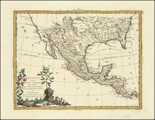
Geography of the McGrudar Chart
The McGrudar Chart sets a new standard for the level of detail depicted in an American produced map of the area. The shear scale of the map is significantly greater than any printed map of the period.
In the decades before the chart was made, Lieutenant Ross's map of the Mississippi, which was the proto-type map of the area during the American Revolution, covered the river from the delta to approximately the area of present-day St. Louis. Twenty years later, Victor Collot's map of 1796 covered the same area as the Ross map, and should be considered authoritative for its time. But neither of these maps show the Lower Mississippi at anywhere near the same scale as the McGrudar Chart, lacking much of the noteworthy human geography recorded by McGrudar. The map is surpassed only by the monumental manuscript maps prepared for the Board of Trade by the British West Florida Surveyor General and Lieutenant Governor Elias Durnford (1770-1771).
McGrudar clearly focuses on information that a riverboat captain would have found most important, which is not surprising given its author. It records major landmarks that were visible from the river and also notes how far upstream from New Orleans they were, labelled with leagues. Plantations, churches, old forts, and villages, many of which are now lost to time, are named in a combination of English and French.
Of the plantations noted, Brengier's Plantation, better known today as L'Hermitage Plantation, was the site of the earliest known Greek Revival plantation house in Louisiana. Fortier's Plantation, also mentioned on the McGrudar Chart, had an impressive West Indies style house facing the Mississippi. It was built in 1784 on Magnolia Lane by Edward Fortier.
One of the more enduring features of the hydrography of the Lower Mississippi is the so-called False River (here bearing its French name "La Fausse Riviere"). This feature was created by Iberville in 1722 by diverting the river to cut through a long and inconvenient oxbow. Unlike many shifts in the river's course, this remains largely unchanged today.
Just north of the False River, on the other bank of the river, a Tunica village is illustrated. The Tunica were a local tribe of Native Americans.
The mapmaker also takes particular care to note the 31st parallel. This was important as that line of latitude served as the northern boundary for Spanish West Florida -- one of the territories that Jefferson had initially hoped Monroe would be able to purchase.
Conclusion
The McGrudar Chart is an artifact of the tremendous historical importance, providing both a greater understanding of the Federalists mindset at the time of the Louisiana Purchase and the visual tool through which Alexander Hamilton and his confederates would have perceived the region shortly after the completion of the Purchase from France.
Previously unknown, except for a single reference in correspondence between Abraham Ellery and Alexander Hamilton, the McGrudar Chart provides fresh source information on one of the last great chapters in Alexander Hamilton's political and professional life and almost certainly his final foray into the international affairs of the United States.


![[ New Orleans, Louisiana / Southern Travel Letter ] Lyman Adams letter to Austin Adams, December 21, 1839](https://storage.googleapis.com/raremaps/img/small/96629.jpg)