


|
||

|

|
|

|
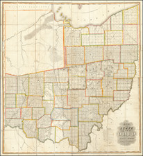
The First Great Map of Ohio
Fine example of the Hough & Bourne map of Ohio, published in Chillicothe, Ohio, prepared by John Melish and printed by Benjamin Tanner in Philadelphia in 1815.
Hough & Bourne's map of Ohio is the second large format map of Ohio (after Mansfield's map of 1807, which measures 30 x 22 inches) and a large format landmark in the history of the mapping of the Buckeye State.
Hough and Bourne were General Land Office surveyors, who took over and improved the work of the surveyor general of the United States, Jared F. Mansfield. Because of his position, Mansfield had access to original working materials of government agents. However, when he issued his Map of the State of Ohio From The Returns In The Office of the Surveyor General (1807), he issued it privately.
Hough and Bourne acquired the copyright to Mansfield's work after he was killed in the War of 1812, then substantially expanded the map and format, based on their own work.
Ristow notes that the Hough & Bourne map is "the first map of Ohio to show all the actual surveys within the inhabited part of the state." As noted by Reese & Miles:
This large and detailed map of Ohio shows rapid progress of the township grid from the original surveys in the eastern part of the state in the 1790s. In southern Ohio some of the areas claimed by land companies established in the colonial period were surveyed and parcelled out prior to 1795, and their irregular patterns, conforming more to topography than geometry, are in strong contrast to the tyranny of the grid. Similar collisions of old and new systems of land tenure and surveying can be seen elsewhere in the country, particularly along the lower Mississippi where a pattern of plantation strips running back from the river established by the French settlers encounters the later American squares. Such patterns in the landscape are best seen from airplanes; they reward the traveller with an atlas and a window seat.
The map is very rare on the market. Since 1940, we note only the Streeter copy (1967) and the Dush Copy (Cowans - 1997).
John Melish (1771-1822) was the most prominent American mapmaker of his generation, even though his cartographic career lasted only a decade. Melish was born in Scotland; he moved to the West Indies in 1798 and then to the United States in 1806. By 1811, he had settled in Philadelphia and published Travels through the United States of America, in the years 1806 & 1807, and 1809, 1810, & 1811, which was richly illustrated with maps.
Melish created several regional maps of the highest quality, as well as the Military & Topographical Atlas of the United States (Philadelphia, 1813, expanded 1815). The latter work is widely considered to be the finest cartographic publication to come out of the War of 1812.
By far his best-known work is his monumental map of the United States of 1816, Map of the United States with the contiguous British and Spanish Possessions. He began working on the map in 1815 and sent it to Thomas Jefferson for comment in 1816. Jefferson enthusiastically reviewed the map and returned it with his edits. Jefferson later hung an example of the map in the Entrance Hall of Monticello and sent it to associates in Europe.
Melish’s finished product was the first map of the United States to extend to the Pacific Ocean. After its publication in 1816, Melish ensured the map was as up-to-date as possible; it was reissued in 25 known states published between 1816 and 1823. The map captured the then rapidly changing geography of the United States, as well as various boundary disputes, treaties, and expansion.
![[Eastern Sheet -- Ohio] Post Road Map of the States of Ohio and Indiana with Adjacent Parts of Pennsylvania Michigan Illinois Kentucky and West Virginia Showing Post Offices With The Intermediate Distances and Mail Routes In Operation On the !st of February 1885 . . .](https://storage.googleapis.com/raremaps/img/small/44153.jpg)

![The State of Ohio with part of Upper Canada, &c. [and Part of Michigan Territory within Ohio]](https://storage.googleapis.com/raremaps/img/small/102945.jpg)