


|
||

|

|
|

|
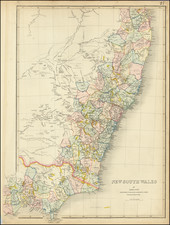
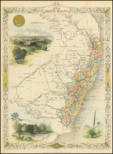
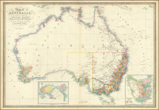
Rare early map of New South Wales, published by John Wyld.
The map appears to be a very early edition of the map.
Wyld's map depicts all of the settled areas of Australia as they appeared around 1840. The main map embraces the area of the modern states of New South Wales and Victoria.
Most of the settlement is concentrated in two regions, the eighteen counties in New South Wales, which then included all of Queensland, centered around Sydney. Victoria remains unorganized and unnamed territory, shown more than a decade before the gold rush.
By this time, the coastlines of the subcontinent were well defined following the explorations of Matthew Flinders and others, however, a majority of the interior remained a complete enigma. Importantly the map depicts the recent discoveries of several explorers, especially with respect to the conspicuous detail in the interior of what in now Victoria and the far southern part of New South Wales.
On various treks from 1824 to 1828, Hamilton Hume, discovered the overland route from Sydney to Port Philipp (the future site of Melbourne), as well as the Darling River, the Murray River's longest tributary. Knowledge of the Murray Basin and surrounding regions was expanded upon by the expeditions of Charles Sturt from 1828 to 1830, and Sir Thomas Mitchell from 1831 to 1836. Mitchell had previously been responsible for the mapping of the settled regions of New South Wales as shown on this map, an achievement for which he received his knighthood.
James Wyld (1812-87) was then one of the world's leading mapmakers, holding the title of official Geographer to Queen Victoria. The present map is one of Wyld's sequences of continually updated maps of Australia and her regions, and are of great historical importance for it played a definitive role in recording the rapid progress of exploration and development during Australia's formative years.
James Wyld Sr. (1790-1836) was a British cartographer and one of Europe’s leading mapmakers. He made many contributions to cartography, including the introduction of lithography into map printing in 1812.
William Faden, another celebrated cartographer, passed down his mapmaking business to Wyld in 1823. The quality and quantity of Faden’s maps, combined with Wyld’s considerable skill, brought Wyld great prestige.
Wyld was named geographer to Kings George IV and William IV, as well as HRH the Duke of York. In 1825, he was elected an Associate of the Institution of Civil Engineers. He was one of the founding members of the Royal Geographical Society in 1830. Also in 1830, his son, James Wyld Jr., took over his publishing house. Wyld Sr. died of overwork on October 14, 1836.
James Wyld Jr. (1812-87) was a renowned cartographer in his own right and he successfully carried on his father’s business. He gained the title of Geographer to the Queen and H.R.H. Prince Albert. Punch (1850) described him in humorous cartographic terms, “If Mr. Wyld’s brain should be ever discovered (we will be bound he has a Map of it inside his hat), we should like to have a peep at it, for we have a suspicion that the two hemispheres must be printed, varnished, and glazed, exactly like a pair of globes.”
![[ Western Australia ] Carte de la Terre D'Edels et d'une partie De Celle D'Endracht (a la Nouvelle Hollande) Dressee Par M. L. Freycinet, Commandans la Goelette le Casuarina. (1801 & 1803) (Rare Separately Published Example)](https://storage.googleapis.com/raremaps/img/small/53267.jpg)