


|
||

|

|
|

|
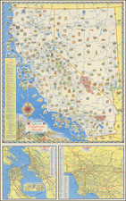
Shale & Sand Oil In the Los Angeles County Basin
Fine early map of part of Los Angeles County, focusing on the Geological and Mineralogical Features of the the region.
In addition to the geology and mineral features of the region, the map shows a number of Ranchos,early railroad lines, roads, and other early Southern California features, prior to the pre-World War II Real Estate booms which would so radically alter the LA Basin.
The map even includes the now infamous "Nigger Slough", south of Gardena (drained and eliminated in 1916 in order to abate the haven for mosquitos), a reminder that Southern California was not imune from the racially charged name choices in the 19th Century.
The map legend notes:
- Metamorphic Sandstone
- Granite
- Conglomerate
- Sandstone
- Shale
- Abandoned Wells
- Oil Sand
- Oil Springs & Brea
- Oil Wells
A nice example of this scarce map, which accompanied a report entitled Oil and Gas Yielding Formations of California, in the State Mining Mining Bureau's November 1900 Bulletin #19.
![(Oil Wells - Santa Fe Springs, Los Angeles County, California) Sante Fee Springs [sic]](https://storage.googleapis.com/raremaps/img/small/95397.jpg)

![(California - 19th-Century Photographs) [Album of 33 photographs of California, Oregon, and Washington, including Yosemite Valley, Stanford University, Sutro Heights in San Francisco; Mt. Hood; Mt. St. Helens; Portland, Oregon]](https://storage.googleapis.com/raremaps/img/small/94083.jpg)
![[ Exceptional original hand-color with highlights in gold ] Typus Aspectuum Oppositionum Et Coniunctionum Etz In Planetis](https://storage.googleapis.com/raremaps/img/small/81866.jpg)
![[Charles Lindbergh - 1st Trans-Atlantic Flight - Printed on Linen]](https://storage.googleapis.com/raremaps/img/small/69233.jpg)