|
||

|

|
|

|
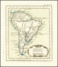
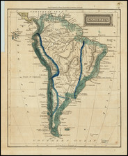
The First Map of South America to Appear in a Large Commercial Atlas
Fine example of De Jode's distinctive first map of South America, engraved by Jan Van Doetecum for the first edition of De Jode's Speculum Orbis Terrarum.
De Jode's map of South America is one of the earliest maps to show the continent of South America alone, and the earliest Dutch map of South America.
The continent is shown in a near-diamond form, covered with mountains and criss-crossed with rivers. It is separated from Terra del Fuego by the thin Strait of Magellan. Central America is also shown with many recognizable place names like Guatimata, or Guatemala. The islands of the Caribbean arc toward the mainland.
The continent itself is split into the kingdoms of Peru, Benzula (Venezuela), Brasil, Chili (Chile), and with New Spain in what is today Mexico. The southern part of the continent is dominated by the Terra de Patagones, or land of the big-footed men, a reference to giant footprints seen by Magellan’s men. These toponyms point to the colonial status of much of the continent at this time, as the Spanish and Portuguese had claimed vast swathes of it in the previous decades.
A glance over the toponyms offers many familiar names, although their placement reflects the still uncertain geographic knowledge about South America that was circulating in Europe in the mid-sixteenth century. The Rio de la Plata delta is exaggeratedly wide and dotted with islands. Quito is in the center of the continent, with Cartagena far inland too. Lake Titicaca, here written as Titicacha, is also nestled deep into the central area of the landmass.
There are two insets tucked into the lower corners of the map. To the left is the metropolis of Cusco, the capital of the Inca Empire before the Spanish conquest. To the right is another important American city, the capital of New Spain. Here it is labeled as Messico, but the Aztecs called it Tenochtitlan. The city was located on floating islands in a vast lake, although little is left of the lake today.
The seas are filled with sea monsters. They are joined by European ships, some in full sail and others engaged in a pitched battle, an indication of the fierce colonial rivalry for the area. There is also a strapwork cartouche in the upper right, bearing the title and proclaiming the map’s publishing privilege.
Sources and rarity
The map is drawn from Forlani's map of South America, which was the first map to depict the interior of the continent in considerable detail and the only map of the continent by the Lafreri School. For the geographical information, Forlani drew in large part on the world map published in 1561 by Giacomo Gastaldi. It was first published in 1562.
The topographical image differs significantly from another map of the same year, Diego Gutierrez’s wall-map of America. Most obviously, the form of the Amazon has changed. In Gutierrez’s map, it is shown like a winding snake, with exaggerated curves. Here, it still undulates, but in a more naturalistic way.
For the geographical information, Forlani drew in large part on the world map published in 1561 by Giacomo Gastaldi.
This map appears only in De Jode's first atlas and was replaced in the second edition with an entirely new map. It is rarely seen on the market.
De Jode and the first modern atlases
This map appeared in De Jode's Speculum Orbis Terrarum, the second general atlas of the world, after Ortelius. In Antwerp in 1570, Ortelius published the first modern atlas; that is, a set of uniform maps with supporting text gathered in book form. Previously, there were other bound map collections, specifically, the Italian Lafreri atlases, but these were sets of maps—not necessarily uniform—selected and bound together on demand.
The first edition of Gerard De Jode’s atlas, Speculum orbis terrae, was published in Antwerp in 1578. Gerard De Jode (1509-1591) released his atlas in a golden age of Dutch atlas production: Ortelius’ atlas was released in 1570, also in Antwerp; the first town atlas in 1572, the first pocket atlas in 1577, the first regional atlas in 1579, the first nautical atlas in 1584, and the first historical atlas in 1595. De Jode’s atlas was intended as competition for Ortelius’. Mercator was also preparing an atlas at the time, and corresponded with Ortelius, but it would not appear in full until 1595, a year after Mercator’s death.
Although the Speculum was ready as early as 1573, it was not published until 1578. This is most likely due to Ortelius’ influence and his privilege over atlas production, which expired just before De Jode finally published. The atlas was the result of collaboration between De Jode, the geographer Jan van Schille of Antwerp, German physician Daniel Cellarius, and the etchers Joannes and Lucas van Doetecum.
Although never as successful as Ortelius’ Theatrum, the Speculum did get republished in a second edition in 1593, two years after De Jode’s death, by Arnold Coninx. After his death, Gerard’s son, Cornelis (1568-1600), and his wife, Paschina, ran the shop. Unfortunately, Cornelis died young in 1600, aged only 32, and the stock and plates were sold to the publisher Joan Baptista Vrients. Vrients had also recently purchased the plates for Theatrum, giving him a monopoly over Antwerp atlas publication. Vrients acquired the De Jode atlas plates only to suppress them in favor of the Ortelius plates, thus the De Jode atlas maps are quite rare on the market today.