|
||

|

|
|

|
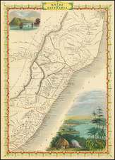
One of Two Surviving Separate Maps of the African Republic of Stellaland
Detailed map of Stellaland, a short lived Boer Republic located near the modern day Botswana, west of the Transvaal, which existed as a country from July 26, 1882 until late 1884, when it was annexed by the Transvaal, shortly before the Transvaal was invaded by Great Britain.
The present map shows just the original Republic, pre-dating the merger of Stellaland and Goshen to form the United States of Stellaland.
The map is drawn from R.A. Lavertine's Map of Stellaland, compiled from inspections, reports and Surveys and published in the Surveyor General's Department in Cape Town, in 1884. OCLC reports the original of Lavartine's map survives in two recorded examples (British Library and University of Leiden).
Stellaland
The Republic of Stellaland was created on July 26, 1882, under the leadership of its elected president Gerrit Jacobus van Niekerk, a farmer from Transvaal, and was given the name Stellaland (Star Land) in reference to a comet that was visible in the skies at the time.
The town of Vryburg was founded and declared its capital. At its founding, the new country was home to an estimated population of 20,500 individuals, 3,000 of whom were of European ancestry.
The State of Goshen, named after the biblical Land of Goshen, was founded by Nicolaas Claudius Gey van Pittius, in October 1882, in the neighboring area called Rooigrond, with the approval of chief Moshette. Goshen had an estimated population of 17,000, of whom approximately 2,000 were of European origin.
On August, 6 1883, Stellaland and Goshen united to form the United States of Stellaland.
Whether the independence of any of these states was ever recognized by another country is not clear. Several British sources refer to van Niekerk and his followers as "freebooters" and "marauders," but recognition from the United Kingdom can be implied from a telegram that was erroneously sent by Sir Charles Warren, military commander for British Bechuanaland, to van Niekerk, in which he endorsed Cecil Rhodes' settlement in Stellaland. Only later did Warren realize that his wording could be interpreted as an acknowledgment of Stellaland's legality, and he tried to deny the message's implications. In February 1884, Great Britain unilaterally declared the area a British protectorate.
Stellaland's laws and constitution were practically identical to those of the South African Republic. It never issued an independent currency, but did print its own postage stamps beginning in February, 1884.
Because van Niekerk's government had announced its intention to levy taxes on all trade going through its territory, Cecil Rhodes, founder of the De Beers diamond company, and the British administration, feared problems for their then mining business, because Stellaland lay on one of the main trade routes. It was also presumed that the small country could eventually be incorporated into the neighboring South African Republic, in an effort to circumvent the Pretoria Convention of 1881, which called for an end to Boer expansionism.
Rhodes even asserted that the area was of such a crucial nature to the Crown that if the territory held by Stellaland remained under Afrikaner control, British presence "should fall from the position of a paramount state in South Africa to that of a minor state." These fears were fueled when, on September 10, 1884, President Paul Kruger of Transvaal declared the area to be under the protection of the South African Republic, and annexed it six days later. In December 1884, the British sent in a force under Sir Charles Warren, who invaded the country and abolished the republic in August of the following year, before it was incorporated into British Bechuanaland.
August Heinrich Petermann (1822-1878) is a renowned German cartographer of the nineteenth century. Petermann studied cartography at the Geographical Art-School in Potsdam before traveling to Edinburgh to work with Dr. A. Keith Johnston on an English edition of Berghaus’ Physical Atlas. Two years later he moved to London, where he made maps and advised exploratory expeditions as they set off to explore the interior of Africa and the Arctic.
In 1854, Petermann returned to Germany to be Director of the Geographical Institute of Justus Perthes in Gotha. There, he was the editor of the Geographische Mittheilungen and Stieler’s Handatlas. The Royal Geographical Society of London awarded him their Gold Medal in 1860. He continued his interest in exploration in Germany, fundraising for the German Exploring Expeditions of 1868 and 1869-70, which sought an open Arctic sea. Tragically, he committed suicide in 1878.
![North Africa [with] South Africa](https://storage.googleapis.com/raremaps/img/small/48322.jpg)