This item has been sold, but you can enter your email address to be notified if another example becomes available.


|
||

|

|
|

|
Stock# 44692
Description
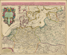
Fine and highly detailed map of western Prussia, now primarily the northwestern part of Poland on the Baltic Sea, including the Bay of Dantzig.
Santini gives credit to a map published in 1775 by the Homann Heirs as the source of the map. This is one of the relatively few maps where Santini does not rely upon French cartographic sources.
Paolo Santini Biography
Paolo Santini (1729-1793) was an Venetian engraver known especially for his religious prints and fine cartographic engravings. He published in Venice and may have a been a member of the clergy. In his maps, he largely adopted and adapted the work of his French counterparts, especially the brothers de Vaugondy.
![(Second World War - Eastern Front) [The Soviet Encirclement of Konigsberg]](https://storage.googleapis.com/raremaps/img/small/65659.jpg)
![(Second World War - Holocaust) Hitlerowskie obozy na ziemiach Polskich w Latach 1939-1945 [Nazi camps in Poland in 1939-1945]](https://storage.googleapis.com/raremaps/img/small/82906.jpg)