|
||

|

|
|

|
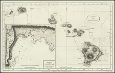
Scarce map of the Big Island of Hawaii, published by Augustus Petermann, illustrating the eruptions of Mauna Loa and Kiluea in 1823.
The map includes topographical details and many place names, mostly along the coast. The map also shows missions, harbors, trails, the boundaries of the lava eruptions in 1823.
The map also includes a number of profile drawings of the two volcanoes.
August Heinrich Petermann (1822-1878) is a renowned German cartographer of the nineteenth century. Petermann studied cartography at the Geographical Art-School in Potsdam before traveling to Edinburgh to work with Dr. A. Keith Johnston on an English edition of Berghaus’ Physical Atlas. Two years later he moved to London, where he made maps and advised exploratory expeditions as they set off to explore the interior of Africa and the Arctic.
In 1854, Petermann returned to Germany to be Director of the Geographical Institute of Justus Perthes in Gotha. There, he was the editor of the Geographische Mittheilungen and Stieler’s Handatlas. The Royal Geographical Society of London awarded him their Gold Medal in 1860. He continued his interest in exploration in Germany, fundraising for the German Exploring Expeditions of 1868 and 1869-70, which sought an open Arctic sea. Tragically, he committed suicide in 1878.

![[Aloha - Christmas Post Card]](https://storage.googleapis.com/raremaps/img/small/67516.jpg)