


|
||

|

|
|

|
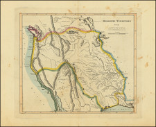
Fine chart of Humboldt Bay, compiled by the United States Coast Survey in 1851.
The chart extends from the town of Humboldt and Red Bluff in the South to Bucksport in the Center and Eureka in the North.
The sounding and anchorages of the Bay are recorded in meticulous detail, along with notes on Sailing Directions, Tides and other navigational information. Below the title is an inset map and a profile view of the Red Bluff entrance to the bay.
The chart is reflective of the booming growth of California, only two years after the 1849 Gold Rush.
The town locates Bucksport, a town which existed for only a few years during the Gold Rush period. Bucksport (also, Buck's Port) was located 2.5 miles southwest of Eureka, on Humboldt Bay. Prior to American settlement a Wiyot village named Kucuwalik existed on the site. The townsite was laid out in 1850 by David A. Buck who was a member of the Josiah Gregg party that explored the bay in 1849. A post office operated at Bucksport from 1855 to 1863.
Fort Humboldt was founded on the bluff over Bucksport in 1853 under the command of Brevet Lieutenant Colonel Robert C. Buchanan. Bucksport was a separate community in the 19th century, before better port facilities and political dominance gave the then northern town of Eureka predominance. The town disappeared by 1870 with the area that once comprised the town remaining only as a neighborhood of southern Eureka.

![[Northern California] North Bay Horse Country](https://storage.googleapis.com/raremaps/img/small/86802.jpg)