The item illustrated and described below is sold, but we
have another example in stock. To view the example which
is currently being offered for sale, click the
"View Details" button below.

1781 Political Magazine
$ 1,600.00


|
||

|

|
|

|
Stock# 44139
Description
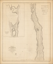
Rare Revolutionary War battle plan, which appeared in the Political Magazine in 1781.
The map shows a number of early forts, batteries and other details around the Chesapeake, including
- Lord C(ornwallis)'s Post at Glocester
- Washington & Rochambeau's Armies
- Lord C's entrenchments between the James River and the York River
- The French Blockade off Cape Henry
Reference
Jolly, D.C. (Brit Per) POL-38.