|
||

|

|
|

|
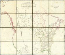
The "Rebel Colonies Now The United States of America" -- One of the earliest printed maps to delineate the boundaries established by the Preliminary Treaty of Peace, January 20, 1783.
Fascinating map of the United States, which identifies location of the region which it references as the "Rebel Colonies Now The United States of America."
This rare map of the United States, originally engraved by John Lodge, was revised with significant new additions in February 1783, becoming one of the first maps to show the new boundaries created by the Preliminary Treaty and the only map to refer to the " Rebel Colonies Now The United States of America." The Treaty of Peace described in this map is the Preliminary Treaty involving the United States, Great Britain, France and Spain, signed by the parties on January 20, 1783, one month prior to the publication of this map, making this map one of the earliest appearances of the boundary scheme between the US, Great Britain and Spain (which obtained Florida in the Treaty).
Contents of the Map
This revised map identifies the following new regions, as established by the Preliminary Treaty of Peace which had been agreed on November 30, 1782, but only signed in Versailles on January 20, 1783 (and not approved by the American Congress of the Confederation until April 15, 1783).
- Rebel Colonies Now The United States of America
- British America By Treaty 1783
- Spanish America (west of the Mississippi River)
- Spanish America (East & West Florida)
It should be noted that the terms of the proposed treaty with the United States were highly controversial and caused a political storm in Britain. The concession of the Northwest Territory and the Newfoundland fisheries, and especially the apparent abandonment of Loyalists by an Article which the individual States would inevitably ignore, were condemned in Parliament. On February 17, 1783, and again on February 21, 1783, motions against the treaty were successful in Parliament. On February 24, Lord Shelburne resigned, leaving the British Government without a Prime Minister. It would be a number of months before the British were able to resolve the impasse.
Originally published in 1780 as:
A New and Correct Map of North America in which the Places of the Principal Engagements during the Present War, are accurately Inserted
This revised edition inserts the new boundaries and identified the the newly acquired lands of each of the Treaty participants. An image of the original map, prior to updating in February 1783, is shown here: http://maps.bpl.org/id/n50604
Rarity / Other Early Preliminary Treaty Maps
This is also one of the very few maps to attempt a mapping of the newly created boundaries of the United States and Britain, during the period between the Preliminary Peace and the final signing of the Articles of Peace in September, 1783, and is preceded only by three other extremely rare separtely issued maps:
- Carrington Bowles' New Pocket Map of The United States of America . . . , (February 4, 1783)
- Thomas Jeffery's The United States of America with The British Possessions of Canada . . . (February 9, 1783)
- John Andrews New Map of the United States of North America . . . (February 12, 1783)
The map is very rare on the market. We locate only a single example on the market in the past 20 years (Daniel Crouch Rare Books Miami Map Fair Catalogue, Item 13, priced at $9,400). The DCRB catalog located the following recorded examples (British Library, State Library of California, Madison Papers--Virginia Historical Society). We also note an example in the Huntington Library, University of South Carolina and University of Wisconsin (American Geographical Society Collection).

![[Unusual Italian Immigrant Communities shown!] America Settentrionale, Centrale e Meridionale -- Carta Dimostrativa Delle Ambasciate, Legazioni, Consolati (Con Le Risettive Circoscrizioni Territoriali), Camere Di Commercio, Agenzie Commerciali, Stazion Enotecniche, Uffici Postali, Ospedali, Scuole Governative e Sussidiate All'Estero](https://storage.googleapis.com/raremaps/img/small/86098.jpg)
![[Early Montana Territory Shown Above Idaho] Johnson's New Military Map of the United States Forts, Military Posts & all the Military Divisions with Enlarged Plans of the Southern Harbors . . . (Shows Military Departments)](https://storage.googleapis.com/raremaps/img/small/93868.jpg)