|
||

|

|
|

|
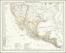
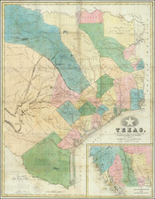
Five maps on one sheet. The most notable being a remarkably detailed printing of Gadsden or Arizona, 6 years before Arizona became a Territory. The earliest mention of Arizona on printed maps is around 1860. Aside from being one of, if not the earliest appearances of Arizona on a map is that the region is confined to the Gadsden purchase, and does not reach the Baylor Line. One if the very few maps to focus on the Gadsden Purchase. The second Norte Americano map tracks the Rio Bravo Del Norte from North of Multero to San Elceario, and showing Socorro, Isleta, Sinecu, El Paso, Fort Bliss, Frontera and other early places. Petermann's maps are often the only attainable examples of important maps of scientific exploration and travel.
August Heinrich Petermann (1822-1878) is a renowned German cartographer of the nineteenth century. Petermann studied cartography at the Geographical Art-School in Potsdam before traveling to Edinburgh to work with Dr. A. Keith Johnston on an English edition of Berghaus’ Physical Atlas. Two years later he moved to London, where he made maps and advised exploratory expeditions as they set off to explore the interior of Africa and the Arctic.
In 1854, Petermann returned to Germany to be Director of the Geographical Institute of Justus Perthes in Gotha. There, he was the editor of the Geographische Mittheilungen and Stieler’s Handatlas. The Royal Geographical Society of London awarded him their Gold Medal in 1860. He continued his interest in exploration in Germany, fundraising for the German Exploring Expeditions of 1868 and 1869-70, which sought an open Arctic sea. Tragically, he committed suicide in 1878.
![[ The First SCORE Off-Road Desert Race Course Maps ] Mickey Thompson's SCORE Parker 400 -- Arizona Side and California Side](https://storage.googleapis.com/raremaps/img/small/97070.jpg)