|
||

|

|
|

|
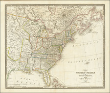
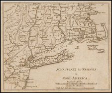
Unrecorded Separately Issued Example of Stockdale's map of the Northern and Mid-Atlantic States.
The map is most notable for the many land grants shown of Western Territory, which then included Ohio, Tennessee and the Old Northwest Territory. The grants include Illinois Company, Army Lands, Wagbash Company, New Jersey Company, Ohio Company, and the 7 Ranges, along with the Donation Lands from the Commonwealth of Virginia and General Clark's Grant 1500 acres.
Many settlements are noted in the West, along with early forts (Miami, Pitt, Venango, Chartres) and other interesting features. St. Louis appears on the map, as does Louisiville, St. Genevieve, New Madrid, St. Philips, Cahokir, and the Kaskaskais Village. A nice post-revolutionary war map of the region.
Separately Issued Variant
The present example bears the note at the left " Se Vend Chez F. Mony a Geneve ." The present example has wide margins and single vertical fold, suggesting it was bound into a composite atlas. Taken together, it would appear that the map was being offered for sale as a separate map in Geneva. The lettering also suggests that it was likely stamped onto the map by Monty, in Geneva, when the sheet arrived in Geneva, and was not added by Stockdale.
A link to a second map from the same set can be found here: /gallery/detail/44063
We know of no other surviving example with this imprint.