|
||

|

|
|

|
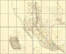
A Spanish New Mexico Rarity
Rare separately issued map of New Mexico, published by Juan Lopez in Madrid.
The present edition is the "dated" edition, described by Streeter as " the rare dated edition, of which the only copy located by Lowery is in the British Museum."
Coming at the end of a long period of Spanish geographical secrecy and at the beginning of the Spanish Enlightenment, this extrarordinary map tipifies the Lopez family quest to publish geographical information which had, for more than 200 years, been retained by Spain as a state secret. The map comprises and amalagam of sources, both published and manuscript, presenting the earliest printed map of what would become the heart of the modern state of New Mexico.
Many early towns are identified, including Taos, Santa Fe and Albuquerque.
The map presents the region of Nueva Granada or Mexico corresponding to the provinces of New Mexico and the Navajo and Moqui Indian controlled regions. In the top left, a long notes provies a comprehensive list of the sources of the map, including printed books and printed maps and a manuscript map of province of New Mexico by an unnamed author. The sources are credited as:
- Juan de Torquenada's Monarquia Indiana (1723 ed--first published in 1615)
- Antoine-Augustin Bruzen de la Martinere's Geographical Dictionary (1735)
- Jean Baptiste Bourguignon d'Anville's map of North America (1746)
- Francisco Lopez de Gomara's sixteenth Century chronicle about the conquest of the Americas (1746 ed, first published in 1552)
- Pedro Murillo Velarde's Geografia Historica (1752)
- a Spanish Translation of Moreiri's dictionary of history (prepared in the 17th Century, but published in 1753)
- Bellin's map of Louisiana (1755)
- Antonio de Alzate y Ramirez's map of North America (1768)
- Antonio de Alcedo's Diccionario geografico historico de las Indias Occidentales (1786)
- Rigobert Bonne's Atlas Encyclopedique (1788)
- Manuscript map "from within the Government of New Mexico", author unknown.
The map is centered on the Rio Grande Valley, from the Cibola National Forest region in the south to north of the Almagre Valley, the depicted source of the Rio Tizon and the Rio de Jesus Maria (in Southwestern Colorado). Dozens of Indian Villages (primarily Comanche in the north and Apache in the south) are shown, along with numerous Spanish Missions.
In the west, the two major rivers (Tizon and Nabajo) are described as flowing into the Gulf of California. A second note opines that the Rio Tizon (or Buena Esperanza), which had been explored in 1765 by order of Tomas Velez Cachupin, the Governor of New Mexico, is likely the Colorado River. These notes are references to the expedition to the Ute Country led by Juan Antonio Maria de Rivera, which crossed the Tizon and the Tegauyo, ultimately reaching the Wasatch Front in Utah. The ultimate goal of the expedition was to locate Lake Copala Gran Teguayo--the reputed seat of a wealthy civilization sought by Coronado-- in the unexplored territory.
The map also identifies a road from the Moqui lands south of the Nabajo River to "Cibola or Zuni."
Rarity
The map is very rare on the market, made all the more interesting by the fact that it was influential in its time. Henry Stevens November 1872 Catalog, Bibliothecha Geographica & Historica . . . entry number 1981 reads as follows:
1981. New Mexico. Mapa Geografico del Gobierno de la Nueva Granada o Nuevo Mexico con las Provincias de Nabajo y Moqui. Por D. Juan Lopez, 15 1/4 by 11 1/2 inches, Scarce, fine copy. Madrid, 1795
With many historical and geographical notes. This copy is from the Humboldt collection, and is probably the very copy he had with him in 1804, at Washington, when he primed Jefferson on the local geography of that vast interior country, and which enabled Jefferson to draw up his admirable instructions to Lewis and Clarke and to Zebulon Pike.
Prior to Heckrotte, we note only two prior examples on the market in the past 100 years:
- Streeter Sale, 1966 (sold for $375)
- Maggs Catalog, 1923, #2267 (10 shillings)
Provenance: Warren Heckrotte Collection, acquired from Jonathan Potter in 1993.