|
||

|

|
|

|
Rare separately issued map of the British Fort St. George and environs of Madras, showing the Siege of September 21, 1746, during the War of Austrian Succession.
The map illustrates the town as it existed prior to its destruction under the orders of Mr. Joseph Francois Dupleix, the French Governor of Pondicherry, following the successful siege of the town by the French. The plan of Fort St. George and its environs are also shown in remarkable detail.
Madras first became a British Fortress in August 1639, when the English East India Company under Francis Day first set up a factor and warehouse with the permission of the local ruler, Damarla Chennappa Nayakudu, the Nayaka of Chandragiri. In 1640, the English built Fort St. George to defend the factory and storehouses.
In 1745, an English Squadron led by Commodore Curtis Barnett was dispatched to attack the French trading settlements in India. In response, the French dispatched Bertrand-Francois Mahe de La Bourdonnais to defend French interests in the region. The two fleets fought an inconclusive skirmish, before withdrawing.
On September 7, 1746, Mahe de La Bourdonnais launched an attack on the British Fortress at Madras. After 2 days of bombardment, the British Governor, Nicholas Morse, sued for peace.
The map is of the utmost rarity. OCLC locates only 3 examples, Bibliotheque National de France, British Library and Deutsches Museum of Munich. Duke University also hold a manuscript version of the map.
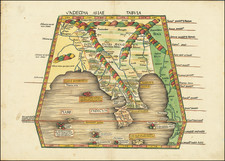
![[Northwestern India & Pakistan] Tabula Asiae IX](https://storage.googleapis.com/raremaps/img/small/46402.jpg)