


|
||

|

|
|

|
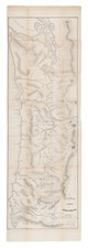
Rare large format map of Oregon Territory, west of the Cascade Mountains, prepared under the direction of John B. Preston, the first Surveyor General of Oregon Territory.
This rare expanded edition was issued separately and did not appear in a government publication, unlike the smaller 1851 edition of the map.
Following the creation of Oregon Territory on August 14, 1848, all grants of claims of land in the territory were nullified. It was not until the passage of the Donation Land Act on September 27, 1850, that new provisions were made for acquiring unclaimed land, to be based upon government surveys. Preston arrived in Oregon on April 20, 1851. On June 7, 1851, Preston drove the "starting stake" for the base surveys of the territory at what is today known as the Willamette Stone. The east-west Willamette Base Line and the north-south Willamette Meridian still define surveying and legal land descriptions in Oregon and Washington state.
Preston's survey team surveyed the lands into squares of a grid, termed a section, which is one mile on each side and includes 640 acres of land-the maximum acreage allowed for a married couple making a claim under the Donation Land Act; a single man could claim up to 320 acres. Thirty-six sections made up a township.
The surveyors took careful note of waterways, hills, prairies, and roads. Some recognizable places are already viable communities. The roads that are mapped include ancient routes such as the California-Oregon Trail, which had sections that paralleled both sides of the valley, as well as newer roads established in recent years. The roads converging on Salem from the outlying farming districts, for instance, reflect its recent importance as a mill town, powered by the waters of Mill Creek.
This significantly revised and expanded edition shows far more detail than the earlier edition, adding topogaphical details, mountains, and far more towns and rivers than the 1851 edition, as well as Ferrys, Mines, and an Indian Agency in the south, near Jacksonville.
The first incarnation of Preston's map is dated October 20th, 1851 and is approximately 36 x 14.5 inches. www.davidrumsey.com/luna/servlet/detail/RUMSEY~8~1~222419~5505425:A-Diagram-of-a-Portion-of-Oregon-Te
This second and significantly enlarged version of the map was published on October 21st, 1852 (48.5 x 16.5 inches), extending to Mount Baker in the north and Smith's River and the Siskiou Mountains in the South, which includes significantly more detail and identifies:
- Townships Subdivided in 1852
- Townships Proposed to be Subdivided in 1853
- Townships Proposed to be Subdivided in 1854
While the 1851 edition of the map appears on the market occasionally, the 1852 edition is extremely rare, this being the second example we have seen on the market (we offered an example in December 2014). The last appearance of the map in a dealer catalog was in a John Howell catalog in 1980 (priced at $200), where the map was described as:
A considerably more detailed and sophisticated version of the preceding surveyor's map, issued for the following year. This printing contains topographical details not present on the 1851 map, and the northern section has been extended to the southern portion of Vancouver Island. It shows the townships that were surveyed in 1852, including the Rogues River gold regions, and those that were expected to be surveyed in 1853 and 1854. The map was lithographed by A. Hoen & Co. of Baltimore, and was issued under the authority of the Surveyor General's Office, Oregon City, October 21, 1852.
Preston would go on to later privately publish Preston's Sectional and County Map of Oregon and Washington West of the Cascade Mountains: compiled from United States surveys and other authentic sources by J.W. Trutch and G.W. Hyde.