This item has been sold, but you can enter your email address to be notified if another example becomes available.


|
||

|

|
|

|
Stock# 43784
Description
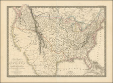
Early map of the United States, pre-dating the appearance of Ohio on the map.
Georgia is still shown extending the Mississippi River.
British East and West Florida appear on the map.
The map shows a massive Western Territory, which would become, Ohio, Indiana, Illinois, Michigan and Wisconin.
Tennasee is mispelled, as was frequently the case in the first view years of its existence.

![The United States of America Confirmed By Treaty 1783 [shows Franklinia]](https://storage.googleapis.com/raremaps/img/small/84491.jpg)